The New Era of Utility Mapping: Global Damage Prevention Summit Recap
Written by

Tamar Shafrir
Published on
October 28, 2025
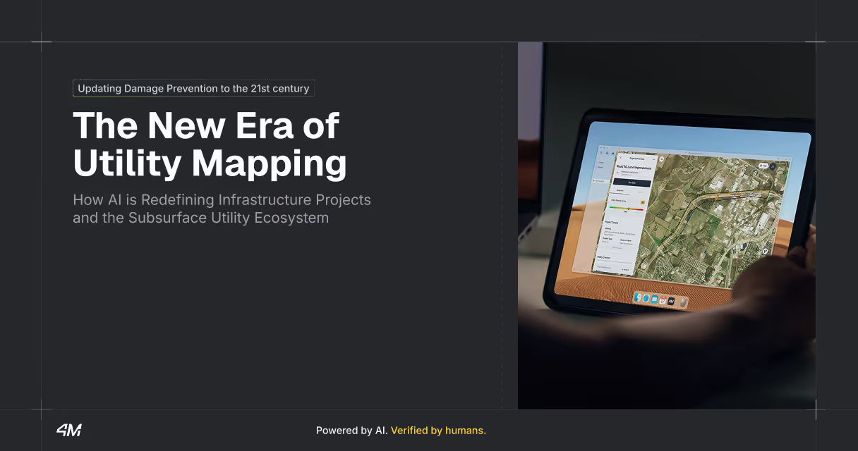
Table of contents
Damage prevention for buried utilities is a global concern. As infrastructure advances and requires more planning and modernization to power our increasingly digital and connected world, there’s a significant need for more sophisticated and reliable methods of utility mapping.
On September 16–18, the ACTS Now Global Damage Prevention Summit convened in Dallas, Texas to solve exactly those industry problems. 4M’s CEO and co-founder Itzik Malta presented a session on the future of utility mapping, exploring how AI is defining infrastructure projects and the subsurface utility ecosystem.
Here’s a rundown of the talk and key takeaways that attendees left with after an inspiring and insightful session.
The Wake-Up Call
Every 62 seconds, a tool or excavator strikes a buried utility line somewhere in the US. In 2024 alone, utility strike damages reached an all-time high of nearly 230,000 incidents—a staggering increase of 15,000 strikes over the previous year. And 90% of utility damage root causes were due to incomplete or inaccurate utility data.
These aren't just numbers. They represent billions of dollars in wasted customer and taxpayer money, construction delays, service disruptions, and most importantly, serious safety risks to workers and communities.
At the Global Damage Preventio Summit, our CEO explored a provocative question that's reshaping the entire utility industry: Does damage prevention still need utility records?
A Glimpse Into the AI-Powered Future
To answer that question, he showed attendees something remarkable: a complete map of water pipelines in Philadelphia generated entirely by artificial intelligence—without using any traditional utility records. By automatically detecting on-surface utility features like manholes, hydrants, and valves, AI was able to connect these points with contextual evidence and fill data gaps where no records previously existed.
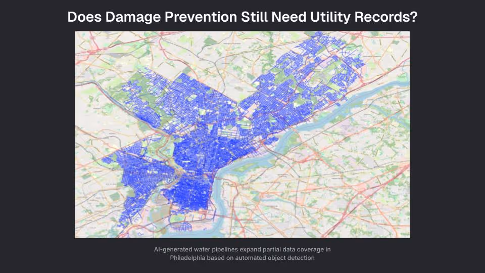
This isn't a far-off dream or science fiction. It's happening right now, and it represents a fundamental shift in how we approach utility locating and damage prevention.
The Truth About AI Transformations
Every commercial and industrial sector is being transformed by AI, and the damage prevention sector now faces a critical choice: adapt or fall behind by sticking to the broken status quo.
The questions every stakeholder must ask are:
- How can my business remain viable and competitive?
- Will my clients trust that my services are innovative and scalable?
- Will I be able to attract employees who want to leverage innovation in their roles?
Failure to adapt to new technologies and tools will have serious impacts on businesses and communities alike. It’s certain that the next 5 years of AI innovation will change our entire industry, and likely for the better.
AI won't replace workers—it is, and will continue to be, a force multiplier for every type of stakeholder involved in utility locating and damage prevention.
Damage Reaction vs. Damage Prevention
The current system is fundamentally broken. We're still taking a reactive approach to damage prevention, only collecting data after it's needed. That data may take days, weeks, or even months to arrive. We continue to separate damage prevention from planning, design, and construction, missing opportunities to collect and share data proactively.
The core issue? We simply don't know where our utility infrastructure is buried.
This knowledge gap creates a cascade of problems:
- Accidental utility damages
- Planning errors and construction delays
- Poor asset management
- Inadequate infrastructure modernization
- Reduced grid resiliency
- Capacity limitations in growing areas
- Lost revenue from service disruptions
Everyone’s Involved, No One’s Aligned
Just one typical right-of-way project can involve more than 50 entities, from project owners and funders to engineers and general contractors, as well as utility owners, subcontractors, locators, insurers, excavator operators, and more.
[insert image from slide 7 of Itzik’s deck]
All of these stakeholders are working with incomplete, outdated, and unreliable utility data. Without a unified platform for collaboration, they can't agree on what lies beneath their feet, and taxpayers and consumers bear the cost.
Today's industry still relies heavily on manual investigations, traditional tools, and limited digitization. There's no central source of truth for utility data that's up-to-date, interconnected, and accessible to all stakeholders.
This leads to three critical problems:
- Lack of repeatable processes: There’s no organized system to improve utility records based on field results, leading to lost opportunities to correct errors, add missing data, and integrate metadata about utility assets.
- Siloed data coordination: Multiple teams respond to dig tickets in the same locations again and again, leading to wasted budgets, lost productivity, and a growing ticket backlog.
- Human error risk: There’s increased room for error when data is manual, unreliable, incomplete, meaning locators may misinterpret blueprints and subcontractors may misinterpret interpret marks on the ground. Even when the 811 system works as intended, there are still elevated risks to people and property every time excavators break ground.
The AI Solution: The Future of Utility Mapping
AI offers a path forward by creating what we call "the operating system of the underground"—a digital language that enables team coordination, accelerated planning, route optimization, and damage prevention simultaneously.
Here's how AI transforms the entire process in the 4M platform:
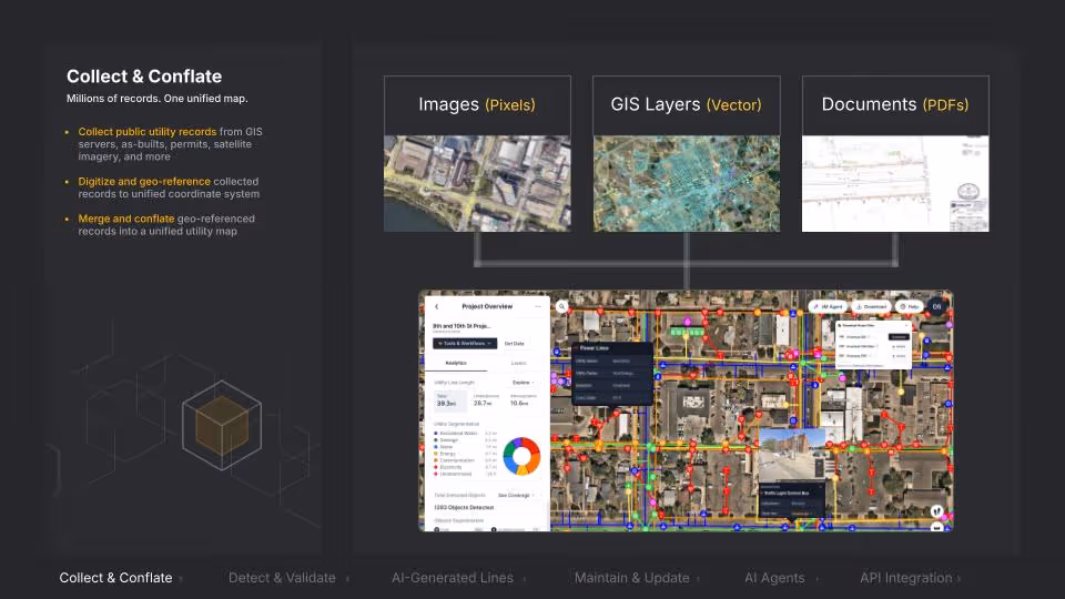
1. Collect & Conflate
We automatically aggregate massive amounts of data across multiple formats—satellite images, street-level imagery, GIS databases, and blueprint packages. AI digitizes, georeferences, and conflates data to remove duplications and correct alignments. We can even improve and augment utility owner records of their own assets, and provide project owners with better data on their own sites, helping everyone work smarter in the future.
2. Detect & Validate
Using machine vision, we identify over 90% of on-surface utility objects through aerial and street-level imagery—manholes, inlets, hydrants, utility poles, and more. We can even use AI to collect roadmarks and retain the data for future use.
3. Generate Missing Lines
We also use AI to examine differences between existing line data and detected utility objects to infer gaps in available information, stitching together subsurface lines that connect aboveground features without the need for records in places of low blueprint or GIS coverage. In the future, we can automatically flag these lines for validation by field locators, concentrating on-the-ground work where it adds the most value.
[insert image from slide 13 of Itzik’s deck]
4. Maintain & Update
Our AI constantly updates the unified map based on new data collection, change detection, and stakeholder collaboration, keeping information current and preventing multiple locating visits to generate the same data.
5. Deploy Intelligent Agents
We’ve developed AI agents that independently analyze utility data and deliver crucial insights and calculations to help planners, estimators, and project managers, from estimating SUE investigation costs to comparing route options and predicting utility conflicts.
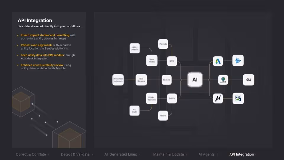
6. Enable Seamless Integration
Finally, we use AI to integrate up-to-date information across software platforms, keeping all stakeholders united around the same data. This allows project owners, engineers, and GCs to synchronize their work in the platforms they’re already using, with the most up-to-date and complete information at their fingertips.
Building Better Together
The ultimate goal isn't to make traditional damage prevention obsolete—it's to help locators deliver verified results with an 80% reduction in cost and time, solving the capacity problem by accelerating when and how we generate and access utility data. That's a 5x multiplier on efficiency that can only be achieved through technological innovation and big data.
And those significant increases in efficiency and data-sharing will help us all build better together.
When stakeholders share data with AI, the benefits compound:
Better early planning and procurement: Project owners can cost-estimate and schedule their capital improvement projects more reliably, while contractors can bid on more accurate PS&E packages.
Faster communication and data access: Engineers gain instant access to comprehensive utility data to pinpoint boots-on-the-ground efforts and coordinate with field workers, and SUE professionals can deliver findings to project owners and engineers faster.
Enhanced collaboration and safety: Project owners can coordinate with utility owners to avoid conflicts and reduce relocations, while contractors can better protect field crews and communities from service and traffic disruptions.
More interoperability: Utility data transfers seamlessly between different software platforms for planning, feasibility studies, project alignment, BIM, and constructability reviews. Public agencies and utility owners can progressively improve their digital records between active project phases, operations, and maintenance.
The Path Forward
The future of utility location is evolving rapidly. With AI deployed alongside traditional Subsurface Utility Engineering and One Call locating processes, we're not just changing how we find utilities—we're transforming early risk mitigation and the entire asset management lifecycle.
The choice is clear: we can continue with reactive approaches that cost billions in wasted spending, or we can embrace AI technologies that create a collaborative, unified, and reliable system that benefits everyone.
It’s our mission at 4M to ensure everyone in the industry is best positioned to benefit from these changes and technologies so we can all build better together. Want to see for yourself how 4M can accelerate the entire project lifecycle? Book a demo today.
Tamar Shafrir
A dedicated researcher that doesn’t stop investigating until she reaches the truth, no matter how hard it is to accept or comprehend (and there are a lot of those in our industry). Tamar took her first career steps in architecture and design, both as a practitioner and a journalist. Throughout her journey, her curiosity has taken her all across the globe, from North America through Europe to the Middle East, discovering and explaining the micro and macro challenges of the industry. Today she focuses most of her efforts on unlocking the challenges of the subsurface, through research and education.
Recent blog posts


Our Newsletter
Join 7k infrastructure professionals
Get monthly insights on ways to build smarter, faster and safer with Utility AI.