Here's What's New in 4M: October 2025
Written by

Chris Garafola
Published on
November 3, 2025


Table of contents
October brought powerful updates that give teams more flexibility, visibility, and control. From enhanced admin tools for managing roles and users, to smarter object detection and more precise data streaming, every improvement was designed to help you collaborate seamlessly, stay organized, and make faster, more confident decisions in 4M.
New Features and Updates
Road Marks Detection
A new evidence layer is now available in 4M: Road Marks extends 4M’s Object Detection capabilities to identify spray-painted surface markings that indicate underground utilities. These markings — the colored lines and symbols locators leave behind — are now automatically detected and displayed on the 4M map.
By connecting above-ground indicators to subsurface data, Road Marks gives project teams a fuller, smarter picture of what lies beneath. The result: more accurate planning, fewer surprises in the field, and safer, faster workflows. Learn more in our Help Article

Custom Roles
Admins can now create, edit, and assign custom roles directly from the Team Management page. By selecting a role hierarchy (based on existing 4M system roles: Project Purchaser, Collaborator, or Viewer), admins ensure users can only invite or assign roles at the same level or below.
Permissions are fully customizable: Admins choose which features and capabilities belong to each role. Unlike system roles, custom roles do not auto-update when new features launch — instead, admins are notified so they can decide whether to add new permissions.
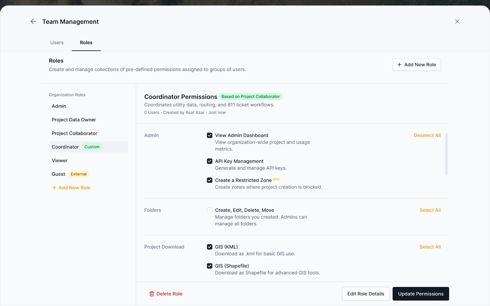
Why this matters: Custom Roles give enterprises flexibility to tailor permissions to departments, teams, or unique organizational needs—enabling scale without compromising governance.
Learn more about how Admins can manage teams and permissions here.
Bulk User Management
Admins can now track, manage, and take action on multiple users from the Active Users or Invited Users tabs in Team Management.
Note that when using Bulk actions, first navigate to the Active Users tab on the Team Management page. Select two or more users, and see the buttons at the upper part of the screen, as shown below.

These new updates include:
- Edit Users’ Roles: In the Active Users tab, click “Edit Role” to change one or more users’ roles to update automatically.
- Remove Users: Click the “Remove” button to remove one or multiple users.
- Pending Invitations: In the Invited Users tab, you can view who was invited, who invited them, and when the invite was sent.
- Resend or Revoke invites: In the Invited Users tab, click a button to resend or cancel invitations if the invite was missed in someone's inbox.
- Copy Users’ Emails: Copy emails to paste in an email or other place.
This eliminates friction when managing users and makes onboarding large teams faster and more reliable.
With the latest Admin feature updates, 4M gives the flexibility, visibility, and governance organizations need to scale. Whether you’re creating a role that fits the permissions that certain people on your team need to do their jobs, or onboarding an entire department, these tools ensure that everyone has the right access at the right time.
Object Detection Updates: Classify Meters
New updates have been made to the “meter” object type: Meters are now classified as Electricity, Gas or Water.
Check out our help article to learn more about Object Detection.
Foundation Data Launched in Michigan and Minnesota
4M’s Foundation Data has been launched in both Michigan and Minnesota—delivering instant, reliable utility data to more projects across the Midwest!
See the map below for the current mapped states (gold) as of November 2025, and the states coming up in 2025 (grey). Don’t see your state? Reach out to your 4M rep to see where it is on our roadmap.

See you next month
That’s a wrap for October. Whether you’re managing teams, streaming data, or mapping your next project, we hope these updates make your day-to-day in 4M smoother and smarter. Explore our help center for step-by-step guides and deeper dives into each update. Stay tuned — we’ve got even more good things coming your way next month to help the industry build better, together with Utility AI.
Recent blog posts


Our Newsletter
Join 7k infrastructure professionals
Get monthly insights on ways to build smarter, faster and safer with Utility AI.