Maximizing Underground Design Efficiency Now and in the Future
Written by
Mike Beehler
Published on
August 21, 2025


Table of contents
Introduction
The United States is embarking on a massive infrastructure build out to support as much as $10 trillion of new investments. Even if just 50% of that total is achieved, that’s still a significant amount of investment.
New auto factories, chip manufacturing plants, drug re-shoring, and the development of huge data centers to support the advent of Artificial Intelligence (AI) and robotics are coming. These new economic development opportunities will require new transportation systems with roads, bridges and ports, new electric and gas transmission lines, new water and wastewater infrastructure, and new fiber for phase one of the projects through their ultimate build-out. The demand will be high. The need will be immediate. There will be no time for lengthy planning, permitting, and design processes. The fast movers will deploy new design and construction technologies at the speed of business. AI-informed designs, building information models (BIM) using 3D–6D models for design, construction, scheduling, cost control and environmental impacts, 3D printing, advancements in material science, new construction equipment married with robotics, and more. It will all impact the safe and efficient construction of the twenty-first-century infrastructure we need to reliably and affordably serve a wide variety of new factories and industries in a competitive world marketplace. It is the future, and we have the opportunity to lead it.
The American Society of Civil Engineers and their Future World Vision encourages members to consider the future in everything we design and build.

Our world is changing at an accelerating pace. Understanding the drivers of change is more critical than ever. Our future will require a new way of doing things. A new plan. A new vision.
A Better Future Means Building Better Together
Subsurface utility engineering (SUE) is the starting point for most infrastructure projects. To achieve a better future, we must change fundamental aspects of the way we work together at the earliest stages of the project. Currently, underground infrastructure projects involve dozens of stakeholders, yet they are not always aligned on basic information fundamental to project success. Even when they’re working on the same job site, each company, consultant, contractor, subcontractor, supplier, and agency may operate in silos and sometimes must rely on incomplete, out-of-date, or missing data. It can be impossible to achieve early alignment as a team when there’s no connective data infrastructure to begin the project from a common baseline and keep shared information updated throughout the project phases.
The challenge of quality SUE seems simple, but the negative consequences are devastating: costly utility strikes, planning errors, construction delays, poor asset management, inadequate modernization of the infrastructure grid, reduced resiliency, lost revenue from service disruptions to utility customers, and more. And the consequences affect everyone. Whether it’s the project owner determining the project footprint, the civil engineer designing the 3D model, the project manager working between the back office and the site, or the excavator operator breaking ground—they’re all held back by increased risk due to the lack of a comprehensive, up-to-date SUE map for every project site.
Today’s methods are no longer sustainable for meeting the demands of building tomorrow's infrastructure. But what if we could change this? What if we could drive better alignment, transparency, and outcomes to bring project stakeholders together from the beginning? When everyone involved can instantly access the same reliable data, projects move forward quickly, decisions become clearer, and outcomes improve. Data alone won’t futureproof underground infrastructure. People, empowered by the same reliable data, will. When everyone shares data, we build better together.
Where to Begin
Where do today’s planner and engineer start?
At the very beginning, of course. What does my project site look like? What is its topography and geology? What and where are the overhead obstacles? Where are the underground utilities? Who owns the surrounding property? A myriad of details that today, in the age of AI, has become increasingly easier to quickly and accurately integrate into an initial, but information-rich, digital twin model.
According to Bentley, “a digital twin is a digital representation of a physical asset, process or system, as well as the engineering information that allows us to understand and model its performance.”
How we answer these early project questions as we build a 3D digital twin can positively impact the planning, design, construction, operations, and maintenance of the project over the life of the asset.
Planning
Planners need immediate access to relative locations to identify overhead features like commercial signs and billboards, utility cabinets, street lights, and even trees as well as myriad underground utilities from all of the utility owners present in the site boundary. Input from Ground Penetrating Radar (GPR), Electro Magnetic (EM) Locators, Real-Time Kinematic (RTK) GPS, and system records can help to provide depths, paths, and positions of underground cables and vaults, water, wastewater, and stormwater pipes and manholes, gas lines, etc. Global Positioning System (GPS), drone and satellite imagery, and utility company records can do the same for overhead obstacles and assets.
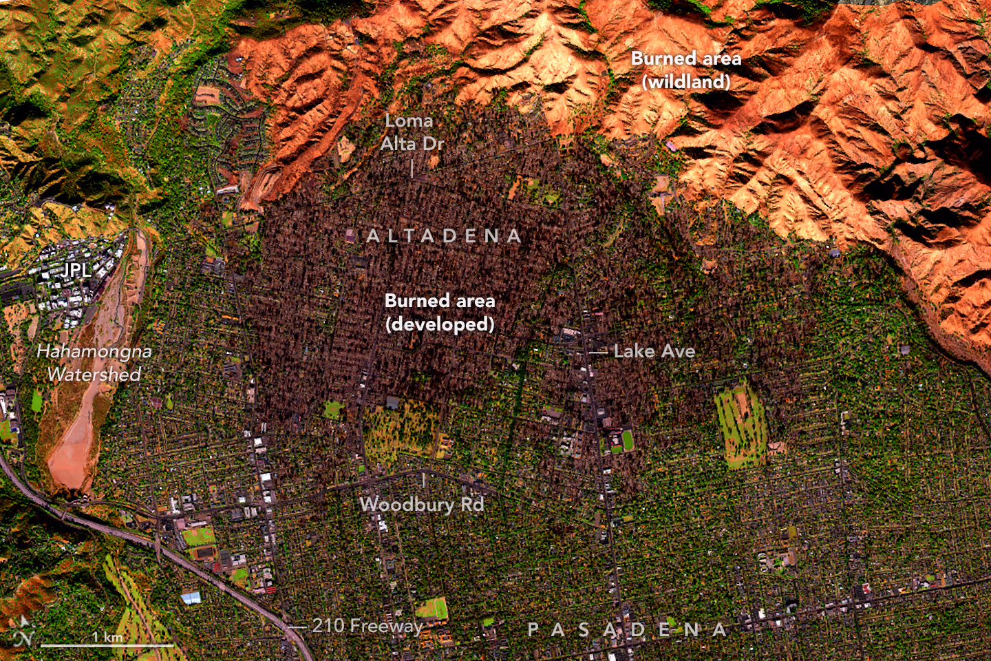
After the devastating January 2025 Eaton fire in southern California, one company, 4M Analytics, searched for the number of underground utilities that were buried under the scarred Earth. They found 16 different utilities, far more than the average planner or engineer might discover.
Planners today need collaborative tools that work across digital platforms producing accurate, data-rich results for application in virtual twins. Good planning work upfront reduces the preliminary and early-stage work for the design teams that follow.
Design
The future of subsurface utility engineering and underground utility location is increasingly data-driven, smarter, and more integrated with emerging technologies than it was in the past. Design teams have many new tools available to improve the quality of their work and the speed of the designs. Here’s a breakdown of how SUE is evolving and what advantages come with high-quality utility location services:
- Integration of AI & Machine Learning:
- Predictive modeling using historical data, GIS, and utility maps to forecast likely utility paths and correct suspected data discrepancies.
- Automatic detection of surface-level utility objects from satellite and street-level imagery using computer vision.
- Smart algorithms for identifying patterns in ground-penetrating radar (GPR) or electromagnetic data.
- AI-powered route planning, design iteration, and comparison of alternative proposals to reduce number and complexity of utility conflicts.
- Advanced Sensing Technologies:
- High-frequency GPR with 3D imaging capabilities.
- LiDAR and drone-based surveys aboveground to correlate surface features with subsurface data.
- More sensitive and automated electromagnetic induction tools.
- Digital Twin Integration:
- Creation of a 3D digital twin of infrastructure, allowing better asset management, real-time updates, and utility mapping for future planning and simulations.
- Cloud-based & GIS Platforms:
- Centralized data repositories with real-time access to utility data.
- AR overlays through tablets, glasses, or phones to see utilities beneath the ground before excavating.
- Blockchain for Utility Data Verification:
- Immutable records for changes in utility infrastructure, reducing conflicts and errors.
These tools represent the state-of-the-art technology available to our industry today. Design teams that deploy such technology for their research into project site overhead and underground conditions will achieve faster and more accurate preliminary results, which will inform important decisions that lead to safer and more efficient construction.

Construction
Every planner and engineer knows that attention to detail in design saves time and money in the field, resulting in less rework and fewer change orders. Accurate obstacle and utility identification and location, whether overhead or underground, leads to safer and more efficient construction for the following reasons:
- Safety: Prevents accidental strikes on gas lines, structures, electrical conductors or cables, or water mains—avoiding injury or fatalities.
- Construction Cost Efficiency: Reduces unexpected costs due to utility obstacles, utility damages, or delays in construction projects.
- Regulatory Compliance: More accurate determination of legal and code requirements for vertical and horizontal clearances and industry standards for safe excavation.
- Asset Management: Helps asset owners, such as municipalities and utility companies, track aging infrastructure and better plan maintenance.
Accurate utility asset and obstacle identification and location services are essential for building and maintaining a reliable digital twin of civil and electrical infrastructure. What tools can be used today to inform this digital twin?
1. High-Fidelity Asset Mapping
- Input from GPR, EM Locators, and Records: These tools provide exact depths, paths, and positions of underground cables and vaults.
- This data feeds into the digital twin’s 3D model to mirror real-world cable layouts, junctions, manholes, and terminations with precision.
2. Real-Time Condition Monitoring Integration
- Sensor Data from Smart Cables & Vaults: Temperature, load, or partial discharge sensors in electric infrastructure can push real-time data to the digital twin.
- Utility locators with RFID or IoT tagging allow the system to locate and monitor specific cable sections and components.
3. Change Detection & Historical Logging
- Dynamic Updates: Any field verification or change detected through utility locating (e.g. after relocation during construction) can be logged and timestamped.
- The digital twin is automatically updated, preserving an evolving and accurate historical record of the network.
4. Risk Analysis & Predictive Maintenance
- Layered Data: The twin can overlay soil conditions, moisture levels, and past fault locations with exact cable routes.
- Helps identify cables at risk of failure and prioritize preventive maintenance.
5. Planning & Simulation
- Impact Analysis: Accurate utility positions allow for precise modeling of load flows, fault propagation, or emergency rerouting.
- Supports planning for network upgrades or load balancing under different scenarios, even in urban cores with dense infrastructure.
6. Enhanced Safety and Coordination
- Excavation Alerts: When an area is flagged for excavation, the digital twin can generate alerts based on exact utility locations and cable types (e.g., high voltage).
All of this technology reduces risk to the public, workers, and existing infrastructure and contributes to a safer and more efficient work environment.

Operations & Maintenance
Operations and Maintenance (O&M) of valuable and often critical infrastructure will start to implement and rely on digital twin models. The digital twin will be built on accurate design, construction, and operational data about our assets. Of course, data is the fuel of the Artificial Intelligence (AI) engine. Civil and electrical infrastructure owners will gain outsized knowledge in the coming years as emerging technologies advance their understanding of the location, condition, and performance of their assets. They will model various high-impact events of varying probability such as hurricanes, tornados, wildfires, and ice storms. They will extrapolate various growth rates of customer usage. They will calculate the optimal strategies and times for vegetation management, road closures, line outages, and system repairs. They will know the moisture content of the soil, the depth of the water table, and the location of natural springs, etc. They will know the soil conditions and the extent and hardness of rock or expansive nature of clay.
The vision of ASCE’s Future World is on the horizon. Some believe that 2025 is a pivotal year in the adoption of currently available technology in pilots and programs that position owners to be competitive and successful.
when underground obstacles are accurately identified and located.
The Future Vision of Asset Mapping
In 10 years, identification of utility assets and obstacles and locating services will look dramatically different—faster, smarter, safer, and more predictive. Here's a vision of our industry by 2035:
1. Digital Twins as the Norm
- Every urban area will likely have a living digital twin with exact locations of all underground utilities.
- Updates will happen in near-real-time via smart sensors, AI-optimized as-built uploads, and automated data syncing from construction projects.
2. Autonomous Locating Robots & Drones
- Ground robots with multi-sensor arrays (GPR, EM, LiDAR, thermal) will patrol or scan construction sites before work begins, during construction, and after project close-out.
- Aerial drones will assist with mapping surface conditions and correlating them with underground data.
3. Augmented Reality (AR) Everywhere
- Field crews will use AR glasses to "see" buried utilities as holograms overlaid on the real world—no more guessing or marking flags.
- Technicians will get real-time depth, type, and utility owner data directly in their viewframe.
4. AI-Powered Data Fusion & Prediction
- AI will integrate data from GPR scans, historical maps, construction plans, and real-time sensors to instantly locate and identify utilities with high accuracy.
- Predictive models will warn of likely errors or undocumented utilities based on ground surface anomalies or inconsistent signals.
5. Blockchain-Verified Utility Records
- Utility location data will be securely shared between stakeholders using the blockchain for data stewardship, transparency, and traceability.
- “Missing,” unavailable, or omitted records will become a thing of the past, ensuring accountability for every update.
6. On-Demand Utility Intelligence
- Digital twins and utility maps will be available via an app where field personnel and contractors can ask questions such as “What is this control cabinet? Who owns this property? What is under the street?” and get instant answers.
- Integration with scheduling software will alert crews to potential underground risks before work is assigned.
7. Deep Subsurface Intelligence
- Inclusion of geotechnical, hydro, and thermal data (especially important for underground electric heat dissipation) will be common.
- This field-available information will further guide not just where to dig, but how to build, based on soil stability, moisture, and thermal conductivity.
8. Full Lifecycle Integration
- From design and permitting through construction and operation, accurate utility identification and location data will be available to all stakeholders from the earliest stages of the project.
- No more separate locate calls—data will be embedded in digital workflows. This could be huge for civil and electrical utilities that eliminate the cost and liability of location services.
The Bottom Line:
Overhead and underground asset identification and locating in 2035 will be:
- Autonomous, with minimal manual labor.
- Highly accurate, using rich, multi-sensor data.
- Integrated, part of a seamless construction and infrastructure ecosystem.
- Predictive and preventive, not just reactive.
- Shared and collaborative, so stakeholders can build better together.
Conclusion
ASCE has the vision. The technology is available. Are you—as a planner, engineer, contractor or system operator—ready to move with us into a safer, more reliable and resilient future with AI and real time, data-rich digital twins of our civil and electrical infrastructure?
Are you ready to help make us competitive in the world marketplace?
Now is the time to act.
Want to take this with you? Download the paper here
Mike Beehler
Mike Beehler & Associates, LLC
Mike Beehler has over 40 years of electric T&D experience at Tucson Electric Power, Hawaiian Electric Company and Burns & McDonnell. He is educated as a civil/structural engineer at the University of Arizona and is a registered professional engineer in eight states.
He currently is the founding member and Chief Opportunity Officer of Mike Beehler & Associates, LLC and serves as the National Spokesperson for the Power Delivery Intelligence Initiative https://www.pdi2.org/. Mike is a Fellow in ASCE and a Member of CIGRE and IEEE.
Recent blog posts


Our Newsletter
Join 7k infrastructure professionals
Get monthly insights on ways to build smarter, faster and safer with Utility AI.