Utility AI Mapping vs Traditional Utility Mapping
Written by

Chris Garafola
Published on
July 7, 2025
.avif)

Table of contents
Remember the days before we all had Google Maps on our phones? We can time-travel back to the days of printing out MapQuest directions, or further back to the 80s when you had to go buy a physical map and chart your course to your destination before you left your driveway.
While these systems worked because they were the best we had at the time (and explorers from the 1600s would have given anything to buy a map from a gas station), the world has evolved significantly since then. And now we have a highly sophisticated mapping system with real-time directions at hand all the time, and it’s made our lives immeasurably easier, and safer in many ways too).
But this revolution in mapping what’s above ground has come slowly for everything that lies underneath, particularly utilities. Traditional utility mapping and investigations based on what served infrastructure teams well enough in the past aren’t the only options anymore. Let’s compare and contrast traditional utility mapping with Utility AI Mapping to see how far we’ve already come and where the future of the industry is going.
Traditional Utility Research and Mapping
The state of traditional utility mapping is pretty dismal. It’s like pulling out a 20-year-old paper map from your glove compartment, hoping that all the landmarks and routes, and highways haven’t changed in that time. If something unexpected pops up while you’re already on your way, you’re facing delays, confusion, and needless re-routing.
The traditional utility investigation process is similar. Here’s what the construction industry is facing with the status quo right now.
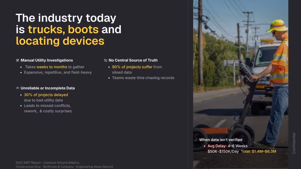
Manual Record Research
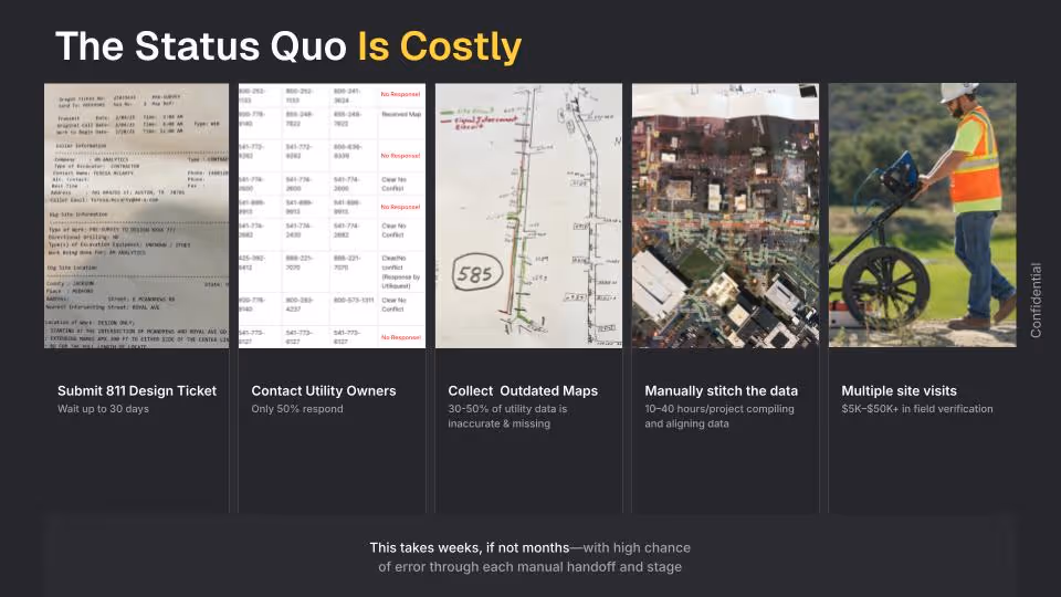
Today, infrastructure teams rely on slow, manual workflows to access critical utility data—weeks or even months spent contacting utility owners, sending repeated follow-ups, dialing 811, making multiple site visits, and piecing together fragmented, delayed responses. To make matters worse, asset owners frequently lack precise knowledge of their own assets, leaving teams without clear guidance and adding further delays.
Systems like 811 have certainly helped, but they’re often overloaded given the demand for construction across the country. 811 Texas is currently getting about 20,000 calls per day, indicating someone is excavating. With that volume of requests, the traditional utility-investigation workflow becomes a critical bottleneck, stalling project schedules and driving up risk.
Of course, it’s possible to advance infrastructure projects without completing a comprehensive utility investigation, but then you run into planning errors, costly rework, and increased risks.
Poor Data Coverage
Meanwhile, the data you do manage to collect is in various formats and is often incomplete, inaccurate, or missing. This is very common: 30% of projects experience delays due to incomplete or unreliable utility data. Projects are at risk from the very start because of those gaps in utility data: the door is open for planning errors, extra field investigations, and inaccurate proposals.
Because of the unexpected unknowns from these gaps in utility data and potential utility conflicts, teams face planning errors, expensive rework, and increased risks. These aren’t just budget line costs; they also cost client relationships and trust.
And even if the data was correct at one point, it’s often not updated even as new projects find old lines or more utilities are built. Traditional utility maps are a static resource, and updating them regularly is challenging.
It’s like using a paper map that doesn’t reflect a new road design: you’ll miss a turn unexpectedly and have to ask someone passing by for directions, making you late (and potentially even later if the person you asked gave you incorrect directions too).
Multiple Sources of Information
Finally, in traditional utility research, you’ll also encounter multiple sources of information and no single source of truth to unify them all.
Siloed data and disconnected workflows reduce visibility and collaboration, leading to delays, misalignment, and inefficiencies that disrupt project scoping, pursuits, and preliminary planning and design. This ultimately jeopardizes constructability and prevents projects from being delivered on budget and on time.
These silod and discounted data sources reduce visibility and alignment from the very beginning of the process as project teams and stakeholders struggle to work toward shared project goals and timelines.
The inefficiencies and delays don’t just come from the search for data across multiple owners, either. Once the data is received, it can come in many different formats, from hand-drawn maps to schematics to blueprints. Someone has to spend valuable time collating all these formats into a single usable source before you can begin bidding or planning, slowing everything down even further.
Utility AI Mapping
The status quo is broken. But fortunately, there’s a better way, which is like replacing your MapQuest printouts floating around your passenger seat with the latest version of Google Maps served on the latest iPhone: utility AI mapping.
A Utility AI Mapping platform is a fundamentally new approach to understanding, consuming, and accessing utility data. And it’s about more than just digitally collecting utility data. It’s about processing and refining it to create a comprehensive, high-confidence map of underground and above-ground utilities, delivered instantly within a digital environment that enables teams to validate and interact with the data, and continuously refine the information too.
Hear how 4M's VP of Product, Amir Hoffman describes it below.
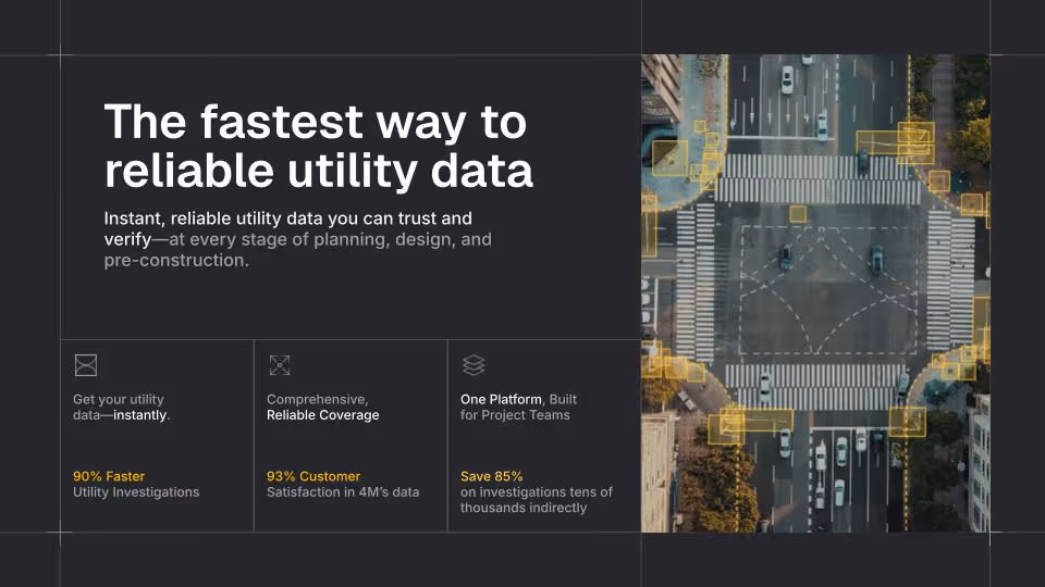
Instant Utility Research
Traditional utility mapping can create weeks or months of delays while waiting for utility information. Utility AI Mapping replaces that with instant, reliable utility data you can trust and verify at every stage of planning, design, and pre-construction.
For MasTec, traditional utility records research ate up valuable time for their team. As Michael, MasTec’s Division VP, said, “Spending time on research took away from our design and research team’s efforts to meet the current year’s design plans.” Using 4M, they sped up their record research by 7 months and their design time by 3 months.
Instant access to reliable data means your teams can plan faster, make confident decisions earlier, and pivot on the fly when project scopes shift unexpectedly. Instead of needing to go back to the utility owner or putting boots on the ground again, you can use 4M and get answers instantly.
Comprehensive, Reliable Coverage
With Utility AI Mapping, you get extensive utility data coverage with intelligent project insights validated by AI and geospatial experts. Thus, you can plan your projects with confidence.
This enables infrastructure teams to:
- Uncover Unknowns Early: Proactively identify utility conflicts and risks upfront to prevent costly surprises during planning.
- Plan with Confidence: Leverage AI-verified utility records and satellite imagery to validate and confirm findings visually in the field.
- Comprehensive Coverage: Access up-to-date utility data, including owner details, above and below-ground lines, key attributes, and on-surface utility objects and markings, to eliminate gaps and incomplete information.
For example, Woolpert got a full utility corridor sketch across hundreds of public and proprietary data sources for their DOT client using 4M, helping them achieve a 50% reduction in field investigation time.
By uncovering unknowns early, you can achieve significant risk mitigation across every stage of the construction lifecycle. Those mitigated risks include safety risks from accidental strikes, risks of delays and cost overruns, and reputational risks from unsatisfied clients as well.
In 4M’s Utility AI Platform, we constantly collect new data, records, permits, engineering documents, remote sensing insights, geospatial data, imagery, and more and incorporate them into our data. We also refresh many parts of the data monthly so it’s a living data source, not a static one, that can be used at every stage of planning, design, and pre-construction.
Easy-to-Use, Centralized Platform
One of the main reasons Google Maps was (and remains) so revolutionary is not just the incredible volume of data it provides to users, from main roads to backstreets and even public transit information. It’s that any user, regardless of their technical sophistication, can pick up a phone and figure out how to use it almost instantly.
Utility AI mapping works the same way in that it’s easy-to-use—anyone on your team can dive in and see value from day one—no steep learning curve required. It also eliminates siloed data and disconnected workflows by providing a single source for utility information in one centralized platform. This helps to eliminate time spent searching across multiple sources, and you can easily export data into GIS and CAD solutions without disrupting your existing projects or workflows.
And you can even show 4M’s data to clients to justify project scope and pricing when questions arise, as LAN did.
The Future of Utility Mapping
Traditional utility mapping is quickly becoming an artifact of the past, like those maps in museums with the monsters at the edge of the seas. In its place, AI utility mapping enables smarter, faster, and safer infrastructure projects. Plus, it’s helping firms build strong client relationships with greater trust and transparency around scope, timing, and constraints.
With better data, better decision-making is possible. Book a demo to see how 4M can help you build smarter, faster, and safer infreastructure today.
Recent blog posts


Our Newsletter
Join 7k infrastructure professionals
Get monthly insights on ways to build smarter, faster and safer with Utility AI.