The New Era of Utility Mapping
How AI is Redefining Infrastructure Projects & the Subsurface Utility Ecosystem
Written by

Jemmie Wang
Published on
February 17, 2026


Table of contents
Introduction
Damage prevention is a crucial principle in the protection and maintenance of existing utility infrastructure during any form of excavation, from roadworks and new utility construction to civilian digging projects. Through state One Call programs, facility owners coordinate with excavators and locators to mark buried utilities in a timely manner before excavation work can safely and legally begin.
Nevertheless, the Common Ground Alliance (CGA) reports that 189,052 unique damages were documented in the U.S. in 2024—roughly one utility strike every three minutes (1). While damage incidents appear to rise in correlation with increased construction and excavation activities (2), the CGA has launched the 50-in-5 challenge to industry stakeholders to reduce damages to critical underground utilities by 50% from 2023 to 2028 (3). The CGA has also highlighted the problem of late locates: in 2024, excavators were delayed an average of 38% of the time due to failure of at least one facility owner to locate utilities present in the excavation site within the mandated window of time (4).
Despite efforts to organize facility owner resources for the protection of buried assets, stakeholders—including facility owners, locators, and excavators—are not becoming more effective at preventing utility strikes, nor are they able to complete locates at a faster rate. One of the fundamental vulnerabilities within damage prevention is the lack of a shared, comprehensive, and reliable digital utility map using cutting-edge technological innovations to increase awareness and accuracy of utility locations across stakeholders, before, during, and after excavation and construction.
We contend that the utility and construction industries and the damage prevention sector will fail to meet the 50-in-5 challenge by 2028 if they apply “business as usual” approaches with only incremental improvements. This white paper examines the potential for a shared, comprehensive, and reliable digital platform for utility mapping using artificial intelligence (AI) to support the 50-in-5 challenge, decrease total damages to utilities across various root causes, and increase utility location data quality and accessibility.
Current Problems and Industry Recommendations for Damage Prevention
Multiple industry and professional bodies including the CGA, the Pipeline and Hazardous Materials Safety Administration (PHMSA), the National Cooperative Highway Research Program (NCHRP), the Transit Cooperative Research Board (TCRB), and the National Association of Regulatory Utility Commissioners (NARUC) have recognized existing problems and offered recommendations to improve the current state of damage prevention and utility coordination more broadly.
Our goal is first to establish commonly recognized problems across the relevant sectors, and second to distill shared recommendations across industry bodies to solve those problems, before demonstrating use cases for technological innovation and AI to support those recommendations. For this white paper, the relevant recommendations involve the collection and processing of utility location data, new mapping technologies, and methods and platforms for notification, data transmission and sharing (5).
Problem 1: Lack of complete and accurate utility maps
There is near universal consensus on the need for accurate and comprehensive utility maps. PHMSA refers to “complete and accurate maps” as “one of the foundations of damage prevention programs” (6). The NCHRP further states, “The consequence of inaccurate or incomplete information about utility facilities can result in…damage to utility installations, which can disrupt utility service, damage the environment, and endanger the health and safety of construction workers and the public” (7).
Current data quality is widely acknowledged to be insufficient for both damage prevention and, in the case of design tickets, planning and engineering needs. According to the TCRB, “the data provided by the One Call systems is typically not accurate or complete enough to make design decisions during project development…highway agencies that rely exclusively on One Call information during project design often experience significant utility issues as projects progress” (8).
Furthermore, the lack of a consistent format for storing utility location data allows discrepancies and gaps in available data to remain unaddressed. Both the CGA and PHMSA recommend implementing GIS/GPS technologies “with real-time map updating capabilities to improve both speed and accuracy” (9) “in locating and documenting the location of underground facilities” (10).
Recommendation: Map utilities accurately and comprehensively using GIS.
Problem 2: Lack of information sharing between stakeholders
The CGA recommends that utility maps be shared with excavators “to improve these workers’ ability to accurately avoid dig-ins to buried utilities” (14) and more generally advises stakeholders to “invest in practices, processes and platforms to…reduce communication friction and provide data that can be leveraged to reduce damages” (15). Similarly, PHMSA promotes “technology…to facilitate stakeholder communication, such as enhanced positive response” (16). PHMSA also notes the importance of communication chains going from excavators back to utility owners so that “installation records of the location and configuration of underground facilities are verified during excavation activities, corrected as necessary, and incorporated into operator GIS on an ongoing basis” (17).
Recommendation: Improve stakeholder collaboration through data sharing.
Problem 3: Lack of participation of water/sewer sectors in damage prevention
Several industry bodies highlight voluntary participation in One Call systems and legal exemptions of certain utility owners and utility sectors as an ongoing impediment to successful damage prevention and a significant contributor to a specific pattern of damages involving accidental strikes or cross-bores when using trenchless technology. The CGA has made it a priority to “address the water/sewer industry’s lack of participation in damage prevention” (18).
The nonparticipation of water/sewer utilities in One Call systems is primarily caused by insufficient resources to map their assets accurately and comprehensively and inability to respond adequately to locate requests associated with excavation tickets. The CGA notes that “mapping access varies dramatically across utility types…with some contractors receiving detailed GIS data while others work with outdated map information or none at all” (19), while the TCRB states that “some utility owners provide electronic copies of their facilities, whereas other utility owners provide only buffer area files” (20). Therefore, the problem involves not only uneven data coverage but also incompatibility of data storage formats, including non-digitized records stored in physical archives.
Uneven participation and inconsistent data coverage contribute to significant risks associated with utility strikes. PHMSA notes that “gas distribution lines have been installed through cross-bores that penetrated unmarked underground sewer lines,” and in the case of a sewer line clog, a “roto-rooter”-type machine may cut the gas line, and “the sewer line can provide a direct path for leaking natural gas to migrate into one or more homes” (21). The CGA also refers to “Katy, Texas, where fiber installation projects damaged 16 water lines in six months because…the water utility was not fully participating in the coordinated marking system, resulting in unmarked water lines in easements” (22). The Katy City Council even placed a four-month moratorium on horizontal directional drilling within city limits due to the elevated number of strikes (23).
These incidents point to the urgency of corrective action, but it is important to recognize the limiting factor that keeps water and sewer utility owners from marking their facilities adequately—as previously stated, the facility owners’ insufficient resources. Therefore, using existing locating techniques with current budget restrictions will not result in full utility owner participation. Aside from acquiring additional funding to support water/sewer mapping initiatives across the country, transformative change means finding new methods to substantially increase utility mapping coverage at lower costs and faster rates.
Recommendation: Enable complete utility owner participation in damage prevention.
Problem 4: Lack of transformative change in damage prevention methods
The need for transformative change through technological innovation is a running theme throughout industry reports. The CGA states that “the time for incremental change has passed…invest in transformation or accept that utility damages will follow pace with construction activity” (24). In 2023, the CGA specifically called for “technological advancements, including mapping, GIS and AI” as potential pathways to achieving the 50-in-5 challenge (25).
PHMSA echoes these recommendations by focusing on “predictive analytic tools,” such as “algorithms, fault-tree models, and other tools…to help identify high-risk locate requests,” and notes that “users of predictive analytic tools report a reduction in damage rates of 20-30 percent” (26). PHMSA observes that such tools are “economically feasible for at least some stakeholder groups,” highlighting the potential for advanced technology such as AI to reduce the cost while increasing the success rate of damage prevention (27).
NARUC argues for a specific use case for AI and machine learning, claiming that “AI can be used as a quality control tool to protect against striking mismarked underground facilities prior to excavation now, and translate the data gathered through machine learning into accurate maps of underground facilities in the future” (28). Not only would this enable improvements and corrections of records “by revising and reconciling the maps…eliminating outliers,” but it would also “reduce the need for in-person visits to apply paint denoting underground infrastructure” (29). Thus, the benefits of AI and machine learning are not only methodological, but also make damage prevention less resource-intensive and more affordable.
These observations point to fundamental considerations for an effective utility mapping platform using AI: it must deliver comprehensive utility location data rapidly, across all utility sectors, and at a cost that maintains profitability for organizations engaged in excavation activities. Without these criteria, facility owners and developers are likely to resort to risk or liability transfer onto excavators or other subcontractors, and thus simply displace the problem instead of addressing it directly (30). AI must not only change how excavators receive information, but how multiple stakeholders collaborate to share and improve utility data throughout the entire construction project lifecycle—before, during, and after breaking ground.
One of the most popular misconceptions of AI is that it will summarily replace human professionals. In reality, labor is in short supply in sectors such as engineering, construction, and locating, and the labor gap will increase dramatically over the next decade as experienced practitioners retire in those fields—taking away valuable knowledge with them. AI is one of the key developments needed to capture current expertise and amplify undersupplied current labor resources. In other words, AI will not replace anyone: rather, it will act as a force multiplier for all stakeholders involved in damage prevention.
Recommendation: Implement advances in AI for transformative change.
AI Capabilities for Damage Prevention Recommendations
AI spans a variety of functions that offer benefits for damage prevention and broader project planning around existing utilities. This section will explore how the four industry recommendations above can be addressed by various AI capabilities, as currently employed by 4M Analytics to map utilities reliably, comprehensively, and at scale. Wider adoption of these AI tools could have a transformative effect on the damage prevention sector, allowing damage reduction goals like the 50-in-5 challenge to be realized by 2028. At the same time, these techniques can elevate and integrate damage prevention as a core component and benchmark of all infrastructure planning, construction and development.
Recommendation: Map utilities accurately and comprehensively using GIS
AI can primarily support comprehensive and accurate utility mapping by automating the aggregation of available utility location data, georeferencing this data, and keeping it up to date. This section looks at two AI capabilities that can support this goal: data collection and change detection.
Data Collection
Using AI in data collection automates a significant amount of research efforts through:
- Aggregation of massive amounts of data in multiple formats, including state and municipal GIS databases, PDF blueprint packages, SUE studies, as-builts, and street-level and satellite imagery
- Georeferencing of data from different map projections into a consistent coordinate system
- Digitization and transformation of pictorial or raster data into vector data
- Merging and conflation of redundant data to remove duplications and correct alignments, leaving unique cross-referenced utility lines and objects.
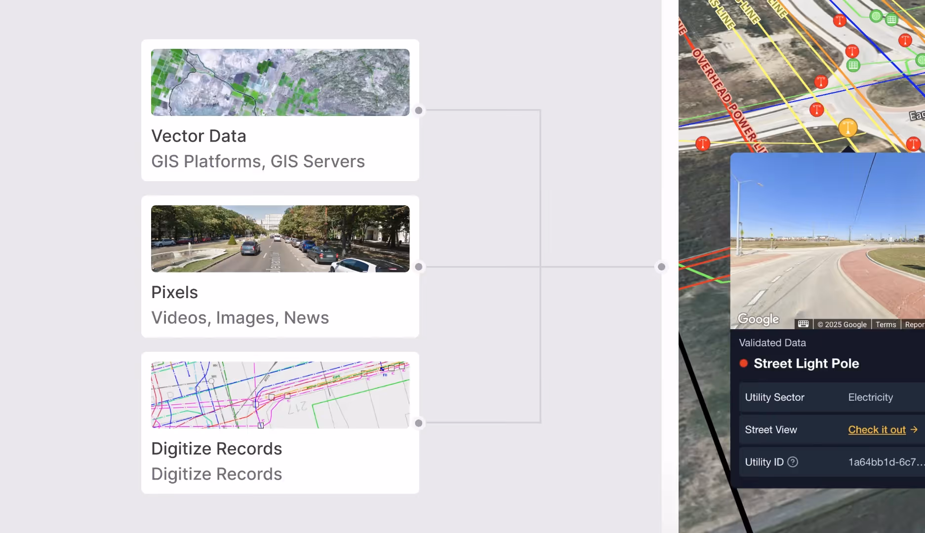
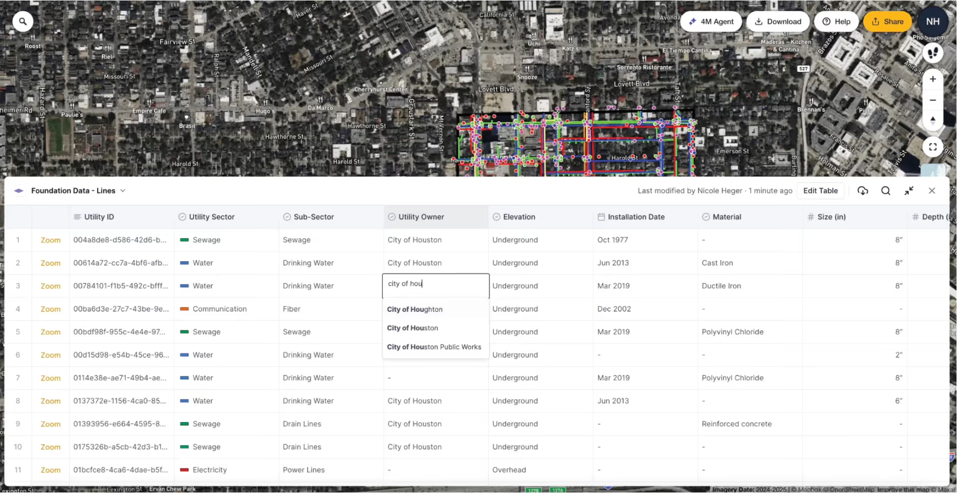
This process allows project owners to amass the most complete set of records for their sites and facility owners for their own networks, while also enabling SUE professionals to quality-control their own QLD data collection results and focus on correcting minor discrepancies between depicted utility lines using expert judgment. Additionally, these results could be shared with excavators to maintain clearance with suspected line locations and thus increase compliance with damage prevention standards.
Change Detection
Maintaining the most updated set of records is extremely time-consuming and labor-intensive when done manually, as it entails referencing existing data sets against hundreds of potential data sources to check for data changes or additions. Meanwhile, change detection using AI is a highly repeatable process, achieving a significant degree of automation and reducing substantial risk of human error and redundant efforts.
For damage prevention, this capability offers noteworthy benefits when it comes to repeated site visits, helping locators to focus their efforts on reported changes since previous locates took place on the same site. AI-powered change detection thus supports the CGA’s recommendation to invest in real-time map updating capabilities.
Recommendation: Improve stakeholder collaboration through data sharing
Comprehensive utility mapping allows for better collaboration and data sharing, because it contains the only data set that spans across traditional record silos by utility type and utility owner. As previously mentioned, these silos allow for discrepancies in coordinate systems, file formats, and data standards to proliferate and remain unchanged despite the availability of more optimal technological solutions.
On the contrary, a digital online platform displays location data for all types of utilities and all utility owners on a single map, making all stakeholders aware of nearby utility lines and features regardless of ownership. Furthermore, various stakeholders can edit the metadata about each utility line if they have additional information to contribute to the collective platform.
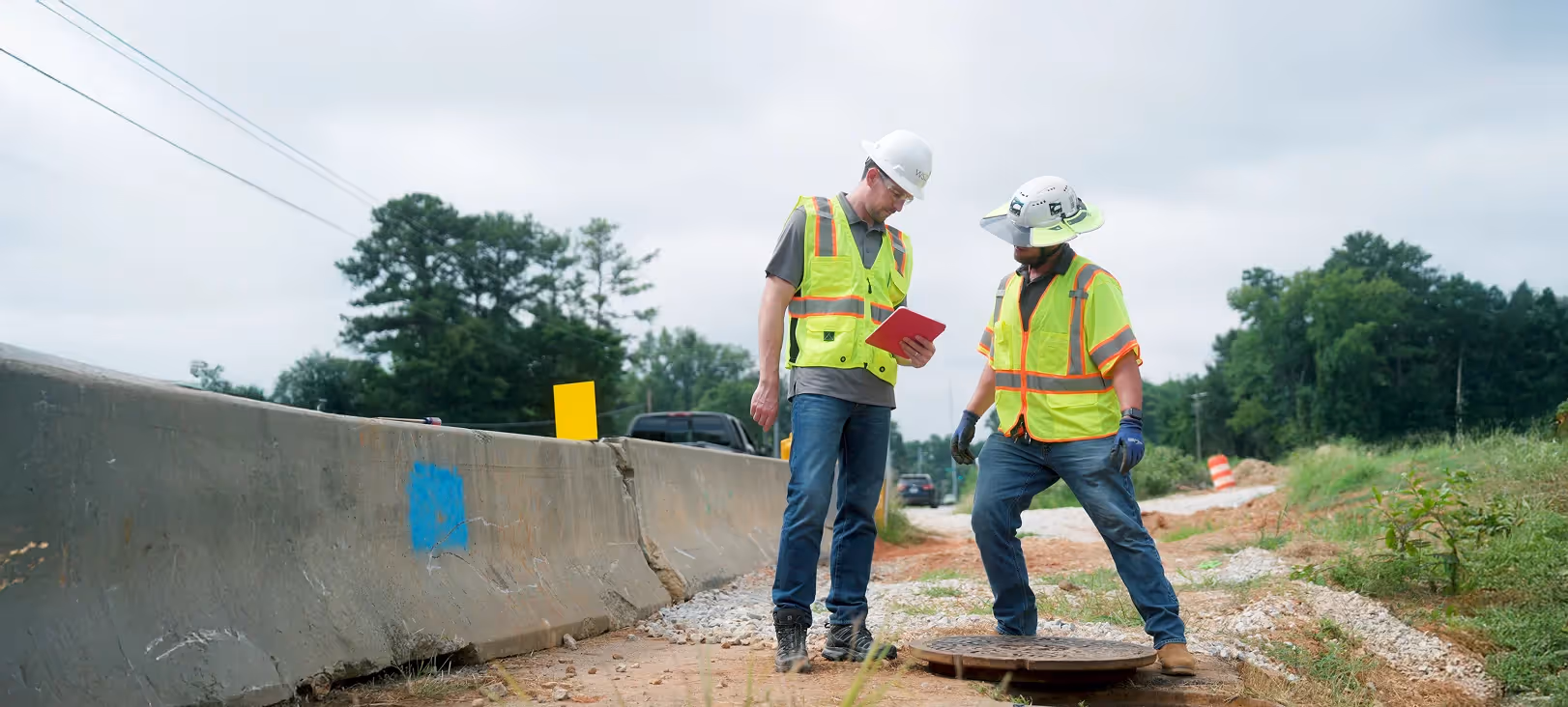
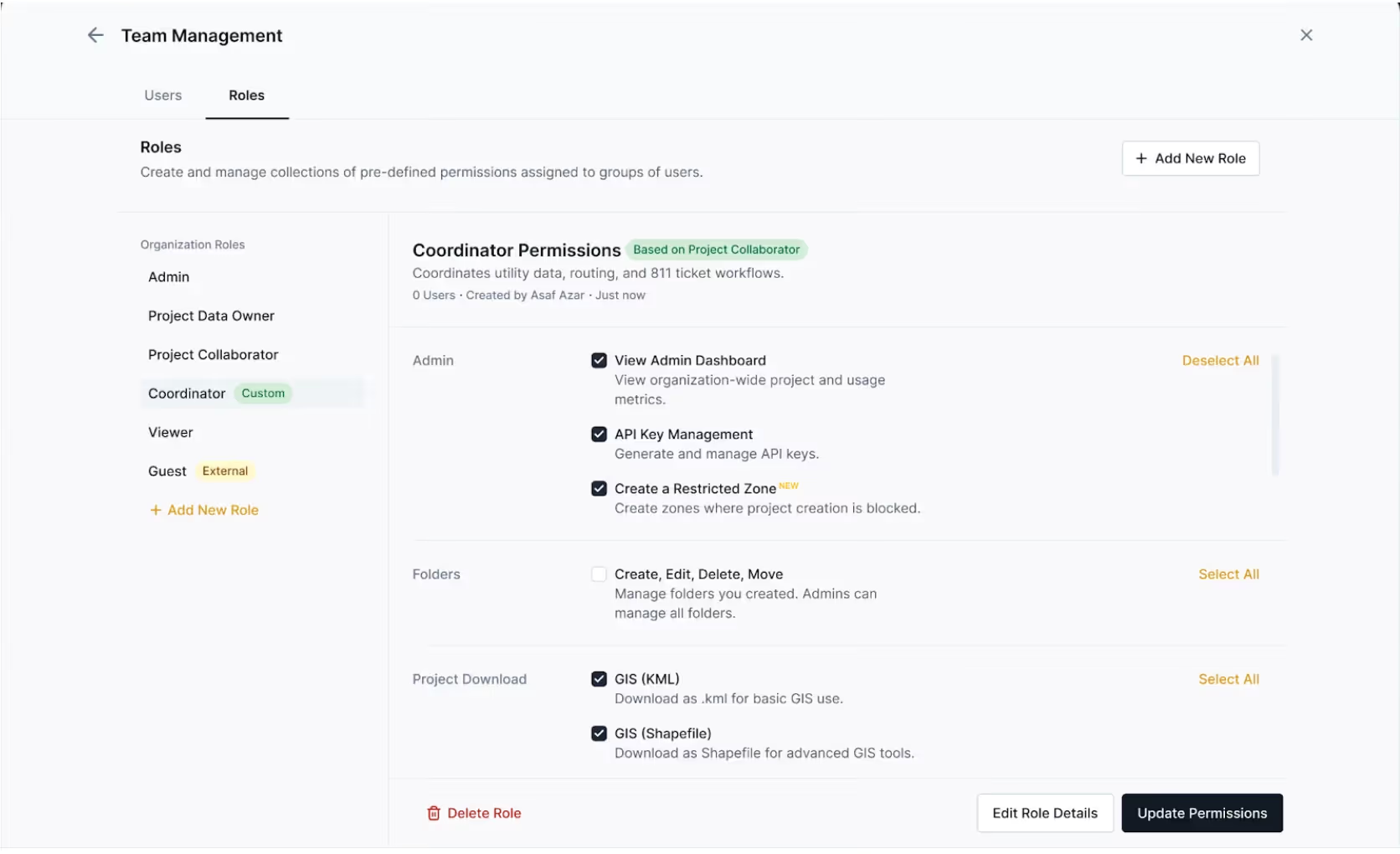
An advanced digital online platform can also be used to improve collaboration by allowing for the assignment of different roles including Admin, Project Data Owner, Project Collaborator, Coordinator, Viewer, and Guest. These roles allow stakeholders from multiple teams to share the same comprehensive data. Stakeholders are not limited to facility owners, but also include project owners, oversight agencies, engineering consultants, general contractors, and subcontractors including excavator operators and locators.
Project collaborators can download utility location data in common file formats such as .kml or Shapefile in order to integrate comprehensive utility maps into their project design files for better quality control during the planning process, thus reducing utility conflicts and increasing awareness of potential utility risk factors. The same can also be achieved through API integration, where data is streamed directly and in real-time between platforms to ensure the most up-to-date information is always displayed.
Recommendation: Enable complete utility owner participation in damage prevention
While existing records are a valuable resource for utility location data, it is widely acknowledged that not all buried assets are depicted on blueprints or as-builts. This points to a vulnerability in damage prevention protocols, especially given the high cost of validating, completing, and correcting existing records through manual investigations and the lack of budget in certain utility sectors such as water and sewer to carry out such activities.
Therefore, any automated techniques for new data generation and validation will have a transformative effect on current asset management performance. In recent years, computer vision has made meaningful advances, allowing massive amounts of image data to be processed using object recognition to identify specific features from image pixels. This means that gaps in data coverage for sectors like water and sewer can be efficiently generated from visible surface features and inferred connecting lines, all before sending locators to the site.
Object Detection & Road Marks
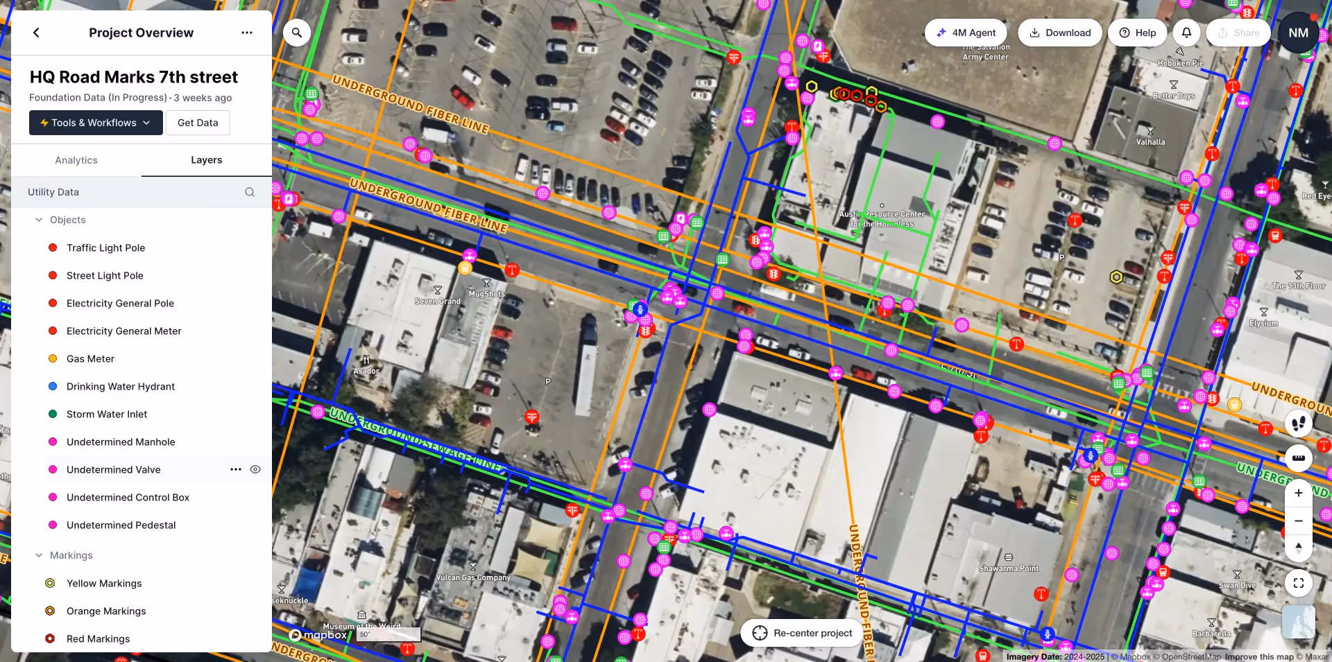
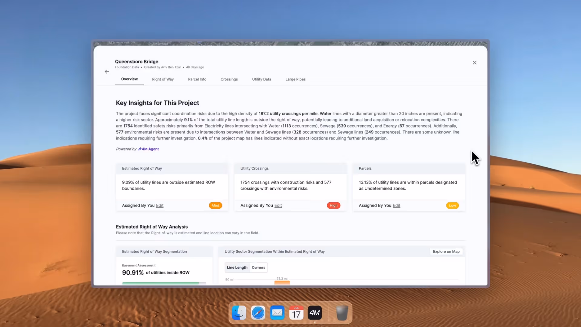
In 2024–2025, 4M launched two noteworthy features using computer vision to identify on-surface evidence of utilities from street-level and satellite imagery. The first feature, Object Detection, identifies utility features such as manholes, inlets, hydrants, utility poles, valves, and more, in order to augment existing records and enrich utility line data with associated objects. 4M’s Object Detection algorithm currently achieves 85% completeness with 95% accuracy, with consistent improvements projected over time.
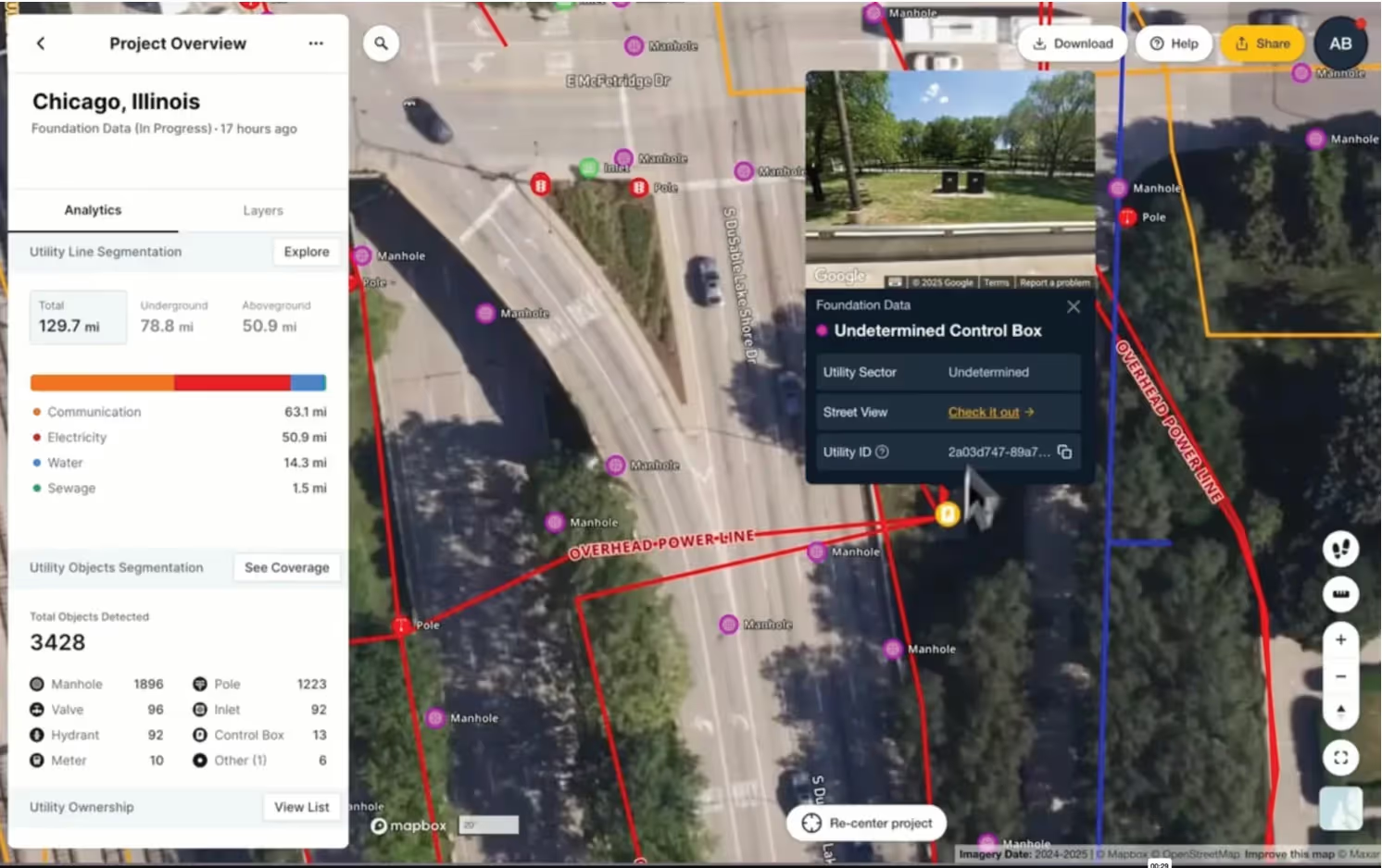
Object Detection allows facility owners to assess and validate their own records, especially in areas with low data coverage. It also enables SUE professionals to quality-control their own Quality Level C (QLC) survey results and ensure capture of complete data. Finally, for sectors known to have incomplete records such as water/sewer, Object Detection can help augment existing data sets to better enable their increased participation in damage prevention programs.
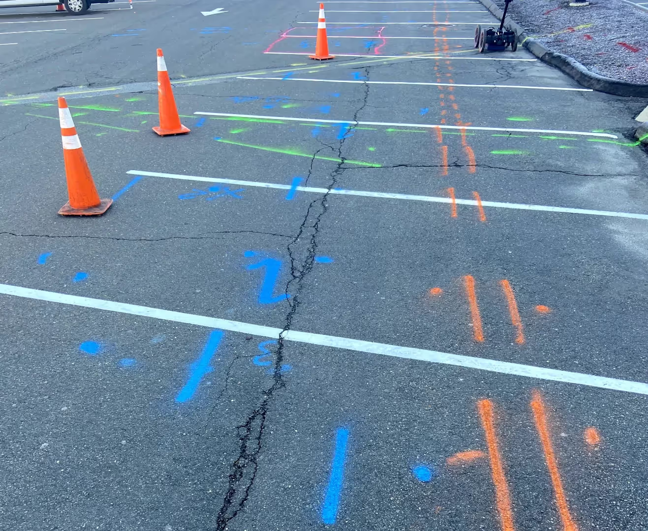
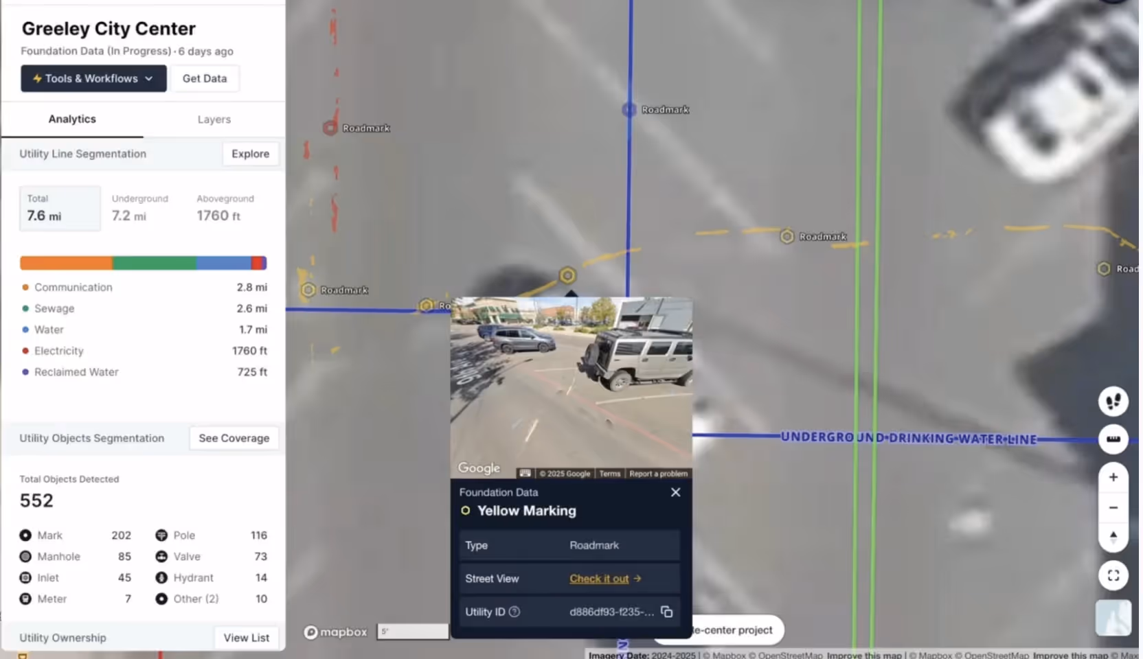
The second feature launched by 4M, Road Marks, identifies historic locating spray marks from street-level and satellite imagery. This feature offers many potential benefits for damage prevention, including retention of physical marks as referenceable digital data, quality control for locators, and continuous improvement of utility owner records over time based on feedback between the field and centralized mapping databases.
AI-Generated Lines
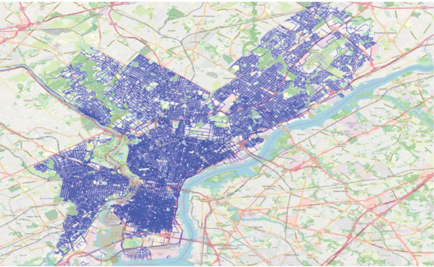
A third feature recently launched by 4M Analytics is the ability to generate utility lines using AI without any supporting records. This feature works by recognizing patterns in identified surface-level utility features to infer the probable existence of subsurface utility lines connecting those features. For example, 4M was able to generate a significant amount of new utility line information to map the water/sewer pipeline network in Philadelphia in the absence of utility record evidence.
areas and sectors with incomplete records. By combining this feature with damage prevention protocol, locators could be directed to quickly validate suspected line locations and consistently increase utility location data over time, thus concentrating time in the field where it adds the most marginal value (especially after repeated site visits). In this way, the use of AI-generated lines can be implemented efficiently at scale.
Recommendation: Implement Advances in AI for Transformative Change
The previous sections have demonstrated that transformative change in comprehensive utility mapping including new utility data generation, as well as new tools for data sharing, can be achieved using AI capabilities. However, AI can also deliver more advanced analysis and predictive modeling through the recent evolution of autonomous AI agents.
AI Agents
Google defines AI agents as capable of reasoning (“using logic and available information to draw conclusions, make inferences, and solve problems”), acting (“to interact with their environment and achieve goals”), observing, planning (“anticipating future states and considering potential obstacles”), collaborating, and self-refining (31).
4M is currently developing multiple AI agents that can independently analyze utility data and deliver crucial insights and calculations to help planners, estimators, and project managers. These range from estimating the cost of a SUE investigation based on the complexity of the project site, to comparing two possible routes for a new utility line by predicting the number of utility conflicts or other high-risk factors.
These agents have the potential to implement damage prevention considerations into wider planning objectives, making safety a factor consistent with other indicators including reductions in cost and budget overruns. By anticipating utility locating efforts with preliminary site data, AI agents allow project owners and planners to take a proactive approach to designing around existing utilities and making decisions based on meaningful data, rather than simply marking utility locations when planning has been completed and design decisions can no longer be amended.
Build Better Together
By combining multiple AI functions and data collection capabilities, and integrating them with damage prevention efforts, stakeholders can build better together. Rather than approaching damage prevention as an incidental obligation, the logic of damage prevention can be seamlessly incorporated into the general pursuit of greater efficiency by minimizing utility conflicts, avoiding unnecessary utility relocations, reducing project delays and obstacles to higher productivity.
Implementation of AI in the field of damage prevention promises to increase data sharing and accessibility, so that utility locations become actionable insights for all stakeholders, from project owners, engineers, and general contractors to utility owners and locators. AI constitutes the transformative change that is necessary to revolutionize damage prevention and achieve ambitious goals such as the 50-in-5 challenge to reduce utility strikes by half by 2028. At the same time, AI offers additional benefits to project planning and execution overall. These include:
Smarter early planning and procurement. Project owners can cost-estimate and schedule their capital improvement plan projects more reliably. GCs and subcontractors can bid on more accurate PS&E packages and protect their bottom line.
Faster communication and data access. Engineers can instantly access comprehensive, reliable utility data in order to pinpoint further boots-on-the-ground efforts and communicate with workers in the field. SUE professionals can deliver their findings to project owners and engineers faster with accelerated blueprint search process for QLD and utility object survey for QLC.
Better collaboration and safety. Project owners can coordinate with utility owners to avoid utility conflicts and reduce utility relocations. General contractors can protect teams and local communities from service disruptions caused by utility strikes and traffic disruptions caused by late discovery of utility conflicts.
Greater interoperability. Utility data is comprehensively and reliably transferred through different software platforms for planning, feasibility studies, project alignment, BIM, and constructability review. Public agencies and utility owners can progressively improve their digital records between active project phases, operations, and maintenance.
With AI, stakeholders can envision a better kind of damage prevention for a rapidly changing world—most importantly, by building better together.
Jemmie Wang
Partner, AcretivPartners LLP
Jemmie Wang is a seasoned finance and strategy executive with expertise at the intersection of technology, operations, and capital markets. As a Partner at AcretivPartners, he has advised leading private equity firms—including Kohlberg & Co and MFG Partners—on investments and successful exits totaling more than $2.4 billion. He also consults with venture-backed startups in the $2.1 trillion U.S. construction sector, as well as Fortune 100 companies.
Recent blog posts


Our Newsletter
Join 7k infrastructure professionals
Get monthly insights on ways to build smarter, faster and safer with Utility AI.