How WSB Helped a DOT Avoid a Multi-Million Infrastructure Disruption and Delay with 4M
Written by

Chris Garafola
Published on
December 30, 2025
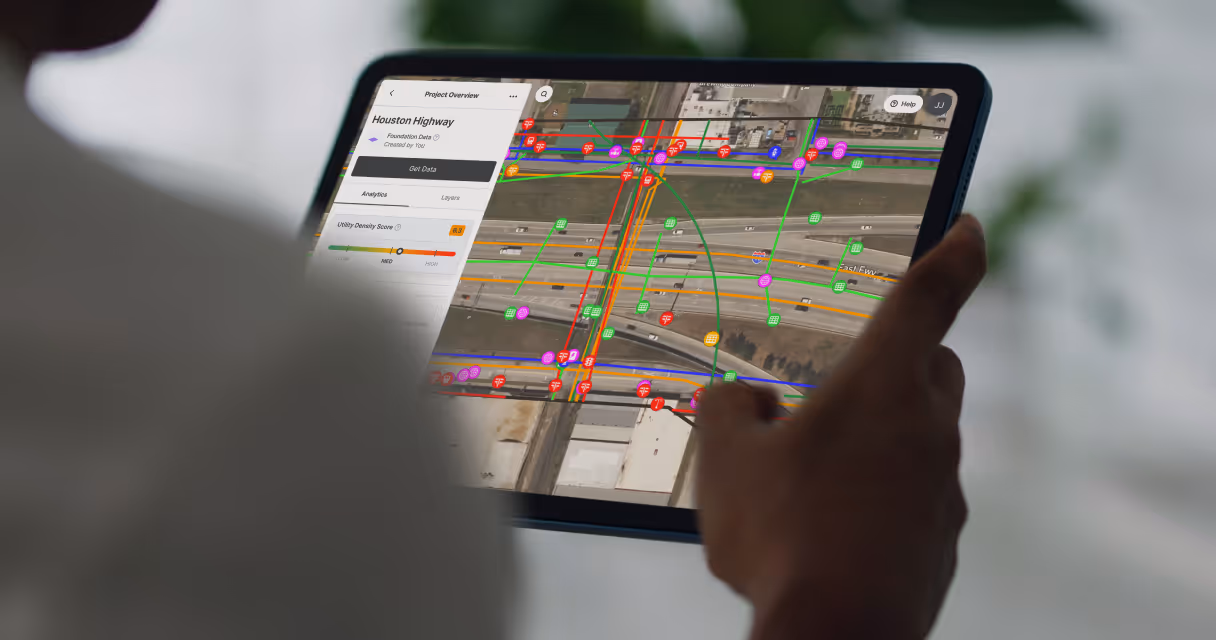

Table of contents
TL:DR
During the planning of a major bridge project in Houston, WSB utilized 4M's utility AI mapping platform to identify a 140-inch-wide sewage line that previous designers had overlooked. The line, buried 55 feet underground, was directly in the path of planned bridge foundations. Traditional survey methods couldn't have detected it at that depth.
The Department of Transportation commissioned a specialized subsurface utility investigation, and confirmed the line's location—avoiding what could have been a significant delay in design with potential impact on parcel acquisition and in the worst scenario, a catastrophic utility strike (and a massive sewage disaster) during construction. The project is getting redesigned around the confirmed utility location, saving taxpayers millions of dollars and months of project delays.
Background: The Houston NHHIP Project
The North Houston Highway Improvement Project (NHHIP) is one of the largest active infrastructure initiatives in Texas. When The Department of Transportation began planning a new bridge as part of this multi-billion-dollar project, engineers followed standard procedures: submitting 811 requests, compiling utility records, and developing initial designs.
The challenge with infrastructure projects at this scale is that engineers must compile fragmented data from dozens of utility owners, municipal databases, and historical as-builts. Even experienced teams working carefully can miss critical information when it's scattered across multiple sources, formats, and tools.
The Challenge: A Critical Line Hidden in Plain Sight
WSB, an infrastructure engineering firm working on the project, used 4M's Utility AI Mapping Platform to conduct additional utility research and investigation. What they found completely changed the trajectory of the bridge design.
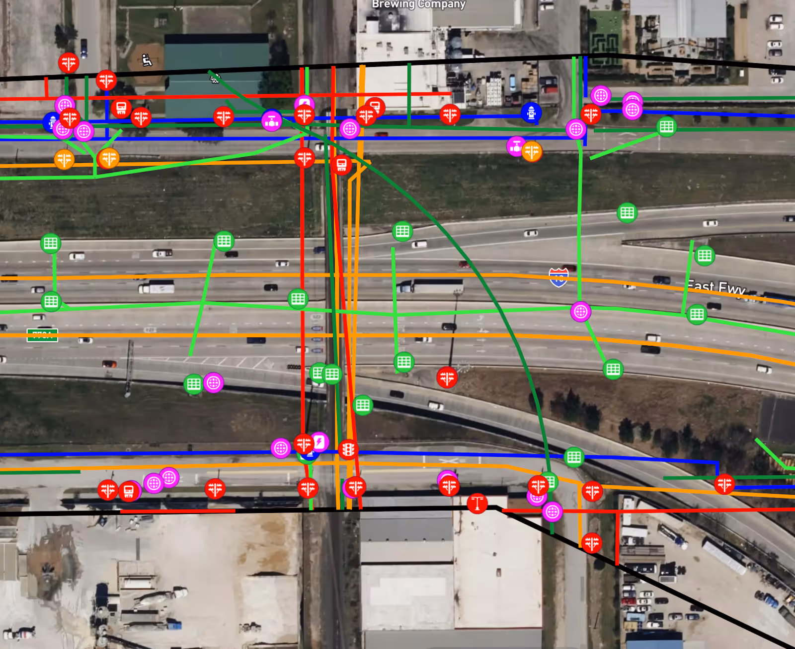
4M's platform identified a 140-inch-wide sewage line running directly through the planned foundation area. The line was documented in public sewage records. But with a dataset as large and complex as the utility inventory for a major highway project, it had been overlooked during initial planning.
This is exactly the kind of gap that leads to costly surprises during construction. A line of this size, carrying partially pressurized wastewater, presents a significant risk of cost overruns, delays, and community disruption if it’s struck during construction.
The Investigation: Confirming What 4M Found
Based on WSB's findings, The Department of Transportation flagged the area as high-risk and paused the project for further investigation. Standard survey methods, such as ground-penetrating radar (GPR) and electromagnetic locators, were unable to help here—the line was buried 55 feet underground, far beyond the reach of surface-based detection technologies.
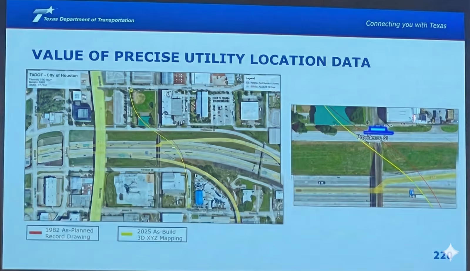
The Department of Transportation commissioned EnviroCal, a company specializing in in-pipe utility mapping, to conduct a detailed subsurface investigation. EnviroCal's process involves physically accessing the line through a manhole and sending instrumented probes through the pipe to map its exact location and condition.
The results confirmed what 4M had indicated. The sewage line was located within a few feet of where 4M's data had placed it—close enough that the planned foundation piles would have created a direct conflict. EnviroCal's investigation also revealed additional concerns: the line is old, corroding, and due for replacement.
What This Means for the Project
The implications extend beyond simply avoiding a utility strike. Bridge foundation locations directly affect span lengths, structural requirements, and overall project economics. When foundation locations change—even by 10 to 15 feet—the type of bridge structure required can change entirely.
A historic brewery building adjacent to the site further constrained the available options for relocating the foundation. The combination of the confirmed utility location and the protected structure means the project team now has the information they need to develop a design that accounts for all site constraints from the start.
Without this early identification, the project could have proceeded to the design phase. Only in a detailed subsurface investigation, which typically happens later in the design phase, the presence of line would have been identified. This could have resulted in re-design of the bridge and also incorrect land acquisition. In the worst case scenario, if the project could have proceeded to construction without identifying this line, at 55 feet deep, even without direct contact, excavation vibrations could have compromised an aging, pressurized sewage line of this size.
That worst case scenario would have resulted in much more than a minor leak. With a critical Houston sewage conduit damaged, there would have been widespread environmental contamination, significant service interruptions, emergency repairs, and substantial cleanup and liability costs. All of this would add up to a major public disruption, in addition to project delays and cost overruns.
How 4M Made the Difference
4M's Utility AI Mapping Platform compiles millions of scattered public utility records into one easy-to-use map. In this case, the sewage line data existed in public records but was overlooked during the planning for this large, complicated project. What 4M provided was the ability to surface that data quickly and present it in context with other project information.
The platform also generates AI-powered risk analysis for projects. For the Houston NHHIP site, 4M flagged a significant risk due to the presence of large-diameter wastewater and stormwater infrastructure—exactly the kind of early warning that allows project teams to investigate before breaking ground rather than discovering conflicts during construction.
WSB then used the 4M data in combination with Bentley Systems tools to create 3D visualizations showing the relationship between the sewage line and planned foundation elements. These visualizations effectively communicated the risk to stakeholders and supported the decision to conduct an additional investigation.
Building Better Together
This flagging of a single pipeline saved Texas taxpayers millions of dollars by avoiding project delays and land acquisition complications.
But this success story is about more than financial savings: it reflects the value of collaboration across the infrastructure ecosystem.
- WSB initiated utility research for the site by creating a project on 4M’s platform.
- 4M provided the early-phase foundational utility intelligence.
- WSB identified the risk, visualized the conflict in Bentley Infrastructure Cloud Connect and communicated it to the owner.
- EnviroCal conducted the specialized investigation to confirm the line's exact location and condition.
- The owner decided to pause and investigate, avoiding a massive crisis.
No single tool or team could have achieved this result on its own. However, by combining AI-powered utility data with engineering expertise and specialized subsurface investigation, the project team successfully mitigated multiple significant construction risks and positioned the project for successful delivery to the Houston community.
Looking Ahead
For DOTs and engineering firms managing complex infrastructure projects, this case illustrates the importance of conducting comprehensive utility research early in the planning process. What made the difference was having a platform that could aggregate, organize, and present that data in a way that made the risk visible.
4M's Utility AI Mapping Platform is much more than just a convenient tool—it’s a critical layer of effective infrastructure planning. It’s designed to provide exactly this capability: instant access to reliable utility data that helps teams plan smarter, identify risks earlier, and deliver projects on time and on budget.
Ready to See What's Below Your Next Project?
Book a demo with 4M to see how Utility AI mapping can help your team identify risks before they become costly surprises.
Recent blog posts


Our Newsletter
Join 7k infrastructure professionals
Get monthly insights on ways to build smarter, faster and safer with Utility AI.