New Regulations on Gathering Lines: Implications for Utility Operators
Written by

Published on
April 10, 2022
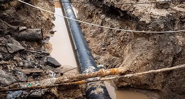
Table of contents
New federal regulations on gathering lines bring with them the potential for major implications for the transmission industry across the United States—and especially in centers of the oil & gas industry like Texas.
Utility stakeholders across the transmission industry need to understand these changes, and should consider the role that utility mapping can play in helping to address the challenges posed by these new regulations.
In this post, we’ll discuss the following points:
- What are gathering lines? How do they differ from regular pipelines?
- How are gathering lines currently regulated? What are the major regulatory changes?
- How can utility mapping help operators identify and locate unregistered lines?
What are gathering lines? How do they differ from regular pipelines?
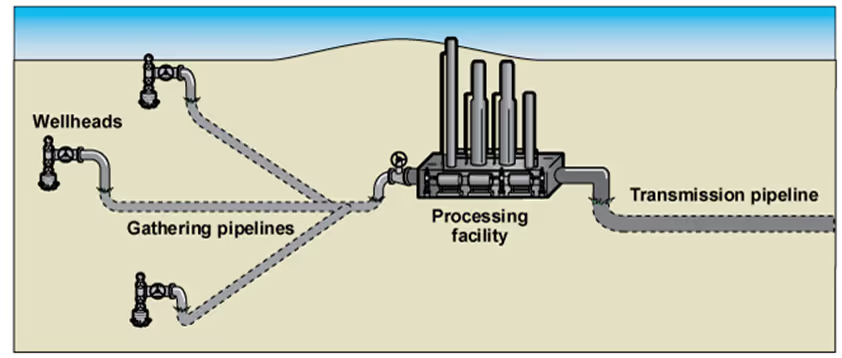
According to the Pipeline and Hazardous Materials Safety Administration (PHMSA), gathering lines are pipelines that “transport gases and liquids from the commodity’s source…to a processing facility, refinery, or a transmission line.” These pipelines tend to use smaller diameter pipes than larger transmission pipelines, and often run through more rural (and less populated) areas. These pipelines differ from flow lines, which bring mixtures of oil, gas and sometimes water from the well to gathering lines.
The federal government and state regulatory agencies have long regulated transmission pipelines, because they transport large quantities of oil and gas, sometimes under extremely high pressures. But gathering lines have grown larger in recent years, and increasingly transport natural gas at high pressures as well. That raises concerns that these gathering lines, which are subject to far less regulation, can pose a growing and unmitigated danger.
How are gathering lines currently regulated? What are the major changes from past regulations?
For decades, gathering lines in rural areas were barely regulated. Even in semi-urban areas, gathering lines were under far less stringent regulations than transmission lines. Gathering lines in most states had low (or nonexistent) standards for pipe thickness, strength, and material—and were generally not subject to reporting requirements.
But as gathering lines have grown larger and more prevalent, state and federal regulatory authorities have started to introduce more requirements for operators.
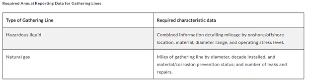
Federal requirements introduced in 2021 by the PHMSA require “all hazardous liquid gathering line operators” to submit annual reports with data on pipeline size and construction material. According to the new regulations, natural gas gathering line operators will also have to begin reporting in 2023.
This marks a big shift for the PHMSA, which until now has only regulated around 18,000 miles of an estimated 426,000 miles of onshore natural gas gathering lines.
But federal regulations are just one element of the story. Since most gathering lines begin and end in the same state, they fall under the regulatory jurisdiction of state pipeline safety agencies, rather than federal jurisdiction (PHMSA). Until recently, state agencies also haven’t kept careful track of gathering lines. According to the Government Accountability Office, “officials with most state agencies …said that they did not require federally unregulated gathering line operators to provide pipeline characteristic data to the state annually.”
In Texas, the state with the most gathering lines in the United States (at least 174,000 miles worth!) the Texas Railroad Commission is responsible for all intrastate pipeline regulation. Several fatal gathering line incidents in Texas in 2018, including one explosion which killed a 3-year-old girl, led to a renewed push for state oversight over gathering lines.
In 2019, the Texas Railroad Commission passed a rule requiring gathering line operators to take “appropriate” action to fix potential safety hazards and to operate gathering lines in a “reasonably prudent” way. This guidance is relatively weak compared to federal regulations and does not require Texas operators to provide the same data that PHMSA requires for cross-state gathering lines. Gathering lines that are entirely on private land and do not cross into other easements are particularly challenging to find.
Texas guidance line operators can find more detailed information in the Railroad Commission’s published pipeline safety regulations here.
What challenges do operators face identifying and reporting on gathering lines? Can subsurface utility mapping help?
The main challenge for operators beginning to comply with new federal and state regulations is the lack of available quality data. Due to changes in pipeline and land ownership, as well as the lack of any centralized annual data on gathering lines, operators are unlikely to have data on hand that meets reporting standards—particularly for older gathering lines.
For this reason, requiring operators to identify and report on all existing gathering lines is a huge request. A January 2022 report by the GAO found that mapping unregistered gathering lines, for many operators, would be a multi -year effort. Doing so could pose a special challenge for small and medium gathering line operators, who don’t necessarily have the resources to obtain mapping data for their lines.
Given that many older gathering lines are built using non-metal pipes without tracer wires, and because many modern pipelines are built using trenchless technology, finding these pipelines can be quite challenging. In 2023, the PHMSA expects that more than 500 operators will need to file reports on natural gas gathering lines for the first time.
Utility mapping technology that blends extensive remote visual analysis and AI can provide a clear first look into subsurface infrastructure—offering a great tool to operators working to identify gathering lines. By integrating a range of data types, including historical satellite imagery, utility mapping can give operators the ability to identify unregistered lines that may have been installed decades ago. As gathering line operators begin working to catalogue unregistered lines, remote utility mapping can provide a compass for their efforts—cutting down the amount of time needed out in the field and helping operators get quality data more quickly.
Recent blog posts


Our Newsletter
Join 7k infrastructure professionals
Get monthly insights on ways to build smarter, faster and safer with Utility AI.