We Use cookies

to enhance your experience with analytics, personalization, and security.

Here's What's New in 4M: July 2025

Written by

Chris Garafola

Published on

August 4, 2025

Product

July turned up the dial on clarity, control, and efficiency—with new tools that give Admins clearer visibility into project usage, expanded detection of on-surface assets like meters and control boxes, and statewide Foundation Data coverage in Illinois to make your day-to-day more efficient, more strategic, and a whole lot less manual.

New Features and Updates

This past month, we rolled out new tools to help Admins track project usage and keep teams aligned—part of our goal to bring every stakeholder together around shared, reliable data.

Project Segments 

In 4M, each project is measured in segments based on the area:

  • Urban areas: 64 acres = 1 segment
  • Rural areas: 640 acres = 1 segment

When creating a project, users now see acreage and segment count before creating new projects for stronger transparency and visibility into segment volume used in each project. 

Admin Alerts & Thresholds

Set project segment usage thresholds (e.g., 80%, 90%) in the Admin Dashboard and get automatic email alerts to stay ahead of your segment volume limit.

Once your organization’s project segment limit is reached:

  • Admins get notified via email and in-app
  • Project creators can create new projects but will not be able to get Foundation data. However, they may view a free heat map (no lines or data layers) in the project area.
  • Option to contact Customer Success to order more projects.

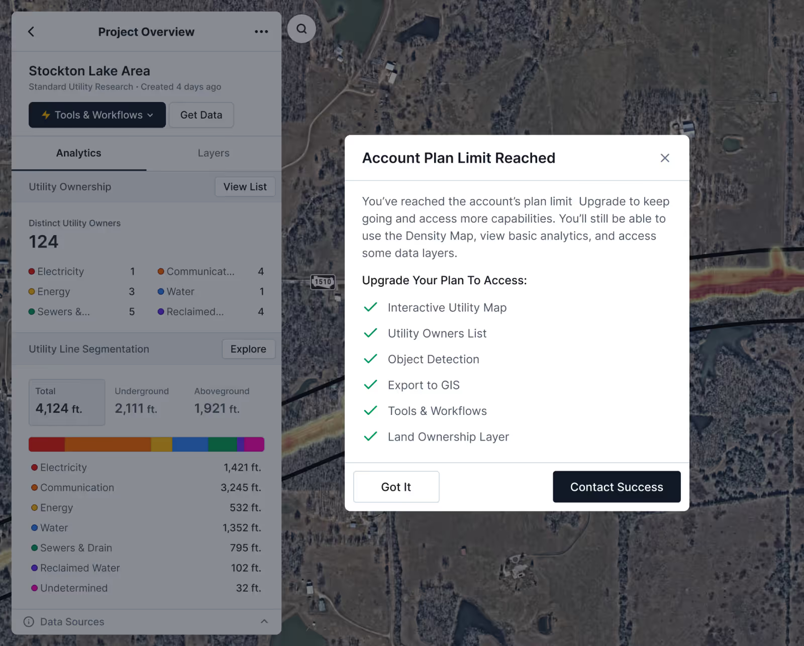
Need more project segments? Your Customer Success Manager is ready to help!

Learn more about monitoring usage in 4M

Object Detection: NEW Meters & Control Boxes

Two new object types are now available with our Object Detection feature: meters and control boxes

Object Detection gives you a clear view of utility objects within your project area so you can make faster, more informed decisions right from 4M. With our detection capabilities and an integrated Google Street Viewer, you can easily identify utility objects and verify their location for further utility evidence and context. 

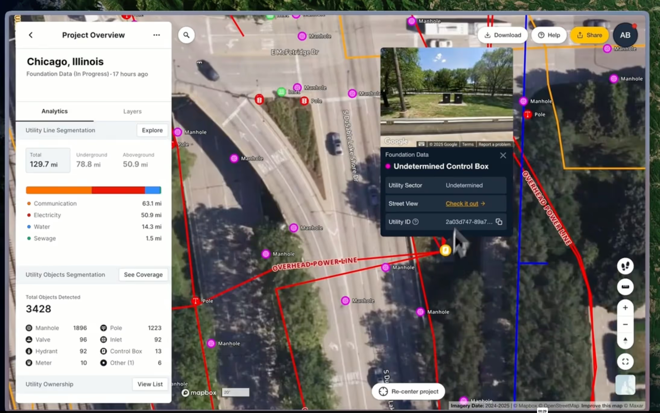
Learn more about Object Detection

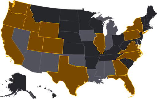
Foundation Data Launched in Illinois

4M’s Foundation Data has been launched in Illinois—delivering instant, reliable utility data to projects across the state. 

See the map below for the current mapped states (gold) as of August 2025, and the states coming up in 2025 (grey). Up next: Foundation Data will be launched in Oklahoma in mid-August!

See you next month

Want to dig deeper into July’s updates? Head to our help center for all the details and a closer look at what’s new.

We’ll be back next month with more ways to help you build smarter, faster, and safer with the only Utility AI Mapping platform.

Chris Garafola

Brand and Content Leader

With over a decade of experience spanning agencies and innovative startups, Chris is a dedicated content marketing leader, driven by the belief that content isn't just about consumption; it's about leaving a lasting impact on the person who engages with it.

Inspired by 4M's mission to create the first online database of subsurface utilities in the U.S., Chris is eager to illuminate one of the infrastructure industry's most pressing issues and champion innovative solutions that deeply resonate with general contractors and civil engineers to address these challenges.

Recent blog posts

View all Blogs

Here's What's New in 4M: August 2025

August brought a powerful new way to give teams flexibility and control with the ability to update utility line attributes in real time. The result? A more dynamic 4M—built to help you plan smarter and push projects forward with confidence. Plus, we launched Foundation Data in Oklahoma!

Chris Garafola

September 2, 2025

Product

Transforming Infrastructure with Advanced Utility Data

Increasing costs on materials and components, rising overheads, compressed timelines, and higher competition for bids—the construction industry has little room for error when it comes to maintaining owner cost-benefit and contractor profitability. Any source of uncertainty must be assessed, quantified, and mitigated to ensure successful outcomes. So why does the number one risk factor for transportation construction projects often go unacknowledged?

Tamar Shafrir

August 21, 2025

Industry Insights

Texas Utility Environmental Risk Report

Underground utility infrastructure plays a critical role in Texas’s environmental and public health efforts. Yet, despite its scale, spanning more than 1.4 million miles statewide, much of this infrastructure remains unmapped or poorly documented. This lack of visibility and incomplete asset management creates challenges for environmental risk management and compliance with evolving regulations. This is especially relevant in the case of utility lines made from high-risk materials that may be prone to failure and corrosion, or harmful to human and ecological health.

August 21, 2025

Industry Insights

Maximizing Underground Design Efficiency Now and in the Future

The United States is embarking on a massive infrastructure build out to support as much as $10 trillion of new investments. Even if just 50% of that total is achieved, that’s still a significant amount of investment.

Mike Beehler

August 21, 2025

Industry Insights

Utility AI Mapping vs Traditional Utility Mapping

Remember the days before we all had Google Maps on our phones? We can time-travel back to the days of printing out MapQuest directions, or further back to the 80s when you had to go buy a physical map and chart your course to your destination before you left your driveway.

Chris Garafola

July 7, 2025

AI Innovation

Our Newsletter

Join 7k infrastructure professionals

Get monthly insights on ways to build
smarter, faster and safer with Utility AI.