How Utility Mapping Can Complement Ground Penetrating Radar (GPR)
Written by

Published on
May 31, 2022

Table of contents
How Utility Mapping Can Complement Ground Penetrating Radar (GPR)
Ground Penetrating Radar (GPR) helps locators detect subsurface utilities non-intrusively and serves as a crucial component of the Subsurface Utility Engineering toolbox. Because the effectiveness of GPR technologies can vary depending on subsurface conditions, remote utility mapping can be used in advance of and alongside GPR scanning to help overcome challenging subsurface environments.
In this post, we’ll touch on the following points:
- What is Ground Penetrating Radar (GPR)?
- Why does GPR effectiveness vary from state to state?
- How can remote utility mapping complement GPR efforts?
What is Ground Penetrating Radar (GPR)?
Ground Penetrating Radar (GPR) is a non-destructive tool that can be used to image the subsurface. GPR works by transmitting electromagnetic waves and receiving the reflected signals as they detect discontinuities. GPR systems can be operated by hand in the field and are sometimes towed on various vehicle platforms.
Because it can effectively detect many subsurface objects, GPR is one of the main tools Subsurface Utility Engineering engineers choose to integrate into their locating projects. In some municipalities in Texas, for example, using a form of GPR is even a legal requirement before beginning the construction phase of a project.
While GPR is a crucial tool and an essential element for many Subsurface Utility Engineering (SUE) projects, it’s not perfect for all situations and all project areas. While GPR is relatively good at locating subsurface utilities, it can only tell you there’s something there—not what type of pipe or line it is. Another limitation of GPR is its tendency to perform less effectively in states with challenging soil conditions, such as Texas.
Why can GPR effectiveness vary from state to state?
Because GPR relies on electric signals that are sent and received through the soil, the soil conditions of a given project site have a major effect on accuracy.
USDA’s National Resources Conservation Service (NRCS) provides suitability scores for GPR use nationwide. They rank the effectiveness of GPR depending on many factors, including soil types. Clay content, salinity, sodicity, and levels of various minerals in the soil can all impact the efficacy of GPR on a project site.
GPR is particularly effective in sandy and gravelly soils, where penetration depths can reach up to 160 meters or about 500 feet. However, in soils with higher clay concentrations, GPR becomes less effective, as it’s more difficult for electromagnetic signals to penetrate the soil. The NRCS suggests that soils with “more than 35 percent clay are restrictive, [and] soils with less than 10 percent clay are generally favorable to deep penetration with GPR.”
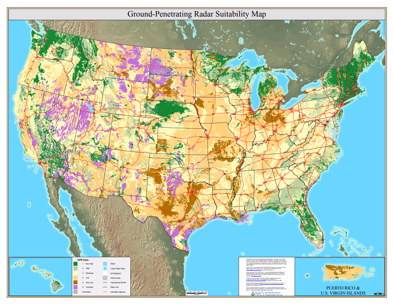
Source: US Department of Agriculture, National Resources Conservation Service, Ground Penetrating Radar Suitability Maps.
In states like Florida and in much of the Northeast, where soil conditions are more suitable, GPR can be a highly effective tool. In states with clay-rich soils, GPR is less helpful for identifying subsurface utilities. In Texas in particular, large swaths of the state can be especially challenging for GPR methods.
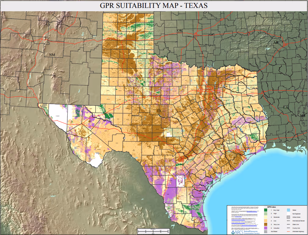
Source: US Department of Agriculture, National Resources Conservation Service, Ground Penetrating Radar Suitability Maps.
For that reason, project managers and SUE experts must often use other methods to identify subsurface utilities, including electromagnetic locating, metal detectors, and sometimes vacuum excavations. Each of these methods has its own advantages and disadvantages.
How can remote utility mapping complement existing GPR methods?
Remote utility mapping that is based on visual analysis can address many of the potential shortcomings of GPR, giving all stakeholders a clearer picture of the subsurface landscape.
Because remote utility mapping relies on visual evidence from satellite and aerial imagery, it can often establish the location of subsurface utilities regardless of different soil types and varying subsurface conditions. And because it is remote, it can provide a preliminary—and large-scale–understanding of the subsurface well before boots-on-the-ground locators begin work in the field.
Combining data from multiple sources and using emerging technologies such as computer vision and AI, utility mapping helps SUE experts resolve differences between as-builts and real-world conditions—and it can empower them to designate subsurface utilities more precisely, cutting down on wasted time and effort boring for utilities in the wrong location. It also provides quality assurance for locators in the field, giving them the data to catch unregistered or abandoned utilities that don’t appear on the as-built records.
While utility mapping technology doesn’t replace GPR, the two can be used together, checked against each other to ensure the best possible predictions about utility line locations. More and higher-quality utility data means better coordination, fewer strikes, and cost and time savings from avoiding project complications.
Interested in seeing how utility mapping can help your next project? Contact us
Recent blog posts


Our Newsletter
Join 7k infrastructure professionals
Get monthly insights on ways to build smarter, faster and safer with Utility AI.