How 4M creates new markets that don’t exist
Written by

Published on
January 29, 2021

Table of contents
Mapping is a tool that has been developing and evolving for thousands of years; from cavemen drawings on rocks, to the first world maps, to Google Maps.
Each evolvement enabled a new set of possibilities that were not available prior; more so, possibilities that were beyond imagination. Initially, maps might have served as tools to explore the world, as nowadays they serve as a tool to locate the closest restaurant.
In our case, 4M analytics has developed the perfect tool to map the subsurface.
It is currently being applied for subsurface utility engineering (SUE) purposes, such as land surveys, utility locating, route concept planning, and others.
It’s a sector in itself that is evidently ripe & ready for disruption but is definitely not the only sector that will be immensely affected by our technology.
Environment
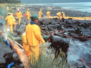
“It has never been ‘if’ a pipeline breaks but rather ‘when’.”
In the vast web of natural gas pipes beneath America’s surface, leaks are found to be a persistent challenge.
Besides the waste of an energy source, gas leaks are highly pollutive, as natural gas (mostly methane) is a powerful greenhouse gas, which is a significant contributor to climate change.
This ongoing reality has made it essential for pipeline owners, regulators, and public officials, to do everything in their power to detect and prevent gas leaks.
Unfortunately, although major leaks are typically fixed quickly, pipeline owners don’t have the resources to locate the smaller leaks, and so they often go unnoticed.
The solution 4M offers in such a case is using 4Map, which scans the pipeline route and detects changes that can be caused by gas leaks; essentially giving pipeline owners a tool to locate gas leaks at scale, allowing them to fix them at scale.
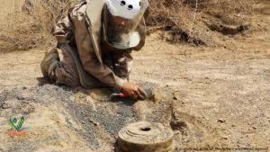
Humanitarian aid
In 64 countries around the world, there are an estimated 110 million landmines, explosive ordinances, IEDs, and cluster munitions still lodged in the ground, waiting to claim their next victim.
In addition to the cost of human lives, they also bring lingering economic and social costs, such as expensive medical treatment, the costs for families caring for injured relatives, obstructing the flow of goods and people, and deeming vast areas of agricultural land unusable.
Unfortunately, clearing minefields, besides being a dangerous task, is a timely operation, and therefore an expensive one, leading to a reality in which not all landmines can be cleared.
The solution 4M offers in such a case is using utility mapping, to scan known or suspected minefields, and detect the exact location of these dangerous ordinances; in this way helping countries and nations free lands that for years were inaccessible due to the remnants of human conflict.
These are just two examples of sectors, suffering from severe issues that are both manually intensive and highly expensive, leading to a reality that may seem unsolvable. In both cases, mapping the subsurface using 4M’s technology tackles the aspects of time and expense, giving mankind a simple solution to what, not so long ago, were complicated problems.
The question now is, which other sectors can our technology impact? Which other problems can we solve?
Recent blog posts


Our Newsletter
Join 7k infrastructure professionals
Get monthly insights on ways to build smarter, faster and safer with Utility AI.