GDOT Utility Workshop: Build Better Together Event Recap
Written by

Chris Garafola
Published on
March 18, 2026
Table of contents
February 25, 2026, was not just an ordinary Wednesday in Atlanta. It was the start of something transformational for the infrasructure industry.
150+ infrastructure leaders in Georgia got together in one room: engineers, utility owners, GDOT leaders, cities and counties, transit agencies, contractors, SUE teams, and technology partners. The room was filled with honest, practical conversations about the partnerships behind every project, big or small, and how we can all build better together.
This was the first stop of 4M’s Build Better Together Roadshow series, and it clearly illustrated both the industry’s biggest challenges and how, when we align people, data, and technology, we can start solving them.
Here’s what happened in that room in Atlanta.
Keynote: Georgia is Winning, and the Stakes are Rising
Nick Fields, GDOT's State Utilities Administrator, opened the day by putting the infrastructure community's work in context. Georgia has held the title of number one state for business for 12 consecutive years. That economic momentum is driving record investment in transportation — and placing unprecedented demands on the people in the room.
Fields walked through GDOT's 2025 accountability numbers: $1.9 billion in total projects delivered, $780 million invested in bridge upgrades across 8,700 inspected structures, $157 million dedicated to highway safety improvements, $576 million in maintenance, and nearly half a billion dollars injected into Georgia's freight program to position the state to double freight capacity by 2050. Add to that the rollout of electric vehicle charging infrastructure, the deployment of fiber along interstates, and the expanding use of AI and automation in utility coordination, and the scale of what's being built in Georgia right now becomes clear.
But Fields didn't dwell on the stats. He used them to make a point about partnership.
Our success isn't measured in miles of asphalt or the number of bridges we build," he told the room. "It's in the strength of the partnerships that forge them.
He addressed every stakeholder group directly. Contractors: your efficiency helps us hit delivery goals. Utility partners: your early coordination is key to preventing delays. Consultants: your expertise in SUE, design, and construction inspection is vital. Local governments: the projects you deliver on GDOT's behalf are moving the needle. Tech partners: you help us challenge the status quo.
Fields closed with a call to think beyond the current moment. This work, he argued, is about legacy — building something that extends beyond any individual career. “It's not about what we get to reap from all of our efforts right now, it's about our families, our kids, and Georgians decades from now who will benefit from things that we're doing today.”
Bridging the Gap — Transitioning Grade Control and Site Development to Current Technology and Practices
The first panel, moderated by GDOT's Sanjan Joseph, tackled a fundamental shift happening across construction: the transition from traditional manual staking methods to GPS-driven 3D grade control. The panelists — Jeff Jacques from C.W. Matthews, Joey Martin from E.R. Snell, Josh Phillips from E.R. Snell, Derek Wilkerson from GDOT, and Matt Bergen from Fayette County — brought a combined century-plus of experience spanning highway contracting, utility coordination, and local government.
The consensus was clear: the transition to modern technology has been transformative. GPS-equipped equipment operators now function as operator-surveyors, working in real time with cut/fill data, project features, and right-of-way boundaries. What once required waiting for survey crews to place slope stakes now happens instantly in the CAD.
But the panel also surfaced the real barriers to adoption. Budget is the most immediate — not just the cost of equipment, but the cost of the people needed to operate the software and manage the data. E.R. Snell's investment in a LiDAR scanner illustrated the tradeoff: the price tag was steep, but it replaced nighttime survey work on active highways. A four-mile corridor that would have taken surveyors all night to shoot was driven and captured in two hours.
The most compelling proof point came from the I-285/I-20 Boulder Crest Road project, where C.W. Matthews shared their TP3 survey control file with Atlanta Gas Light and their contractor. AGL was threading a high-pressure steel gas main through a corridor with 16 utility owners, multiple wall alignments, storm drain crossings, and limited right-of-way. By using the contractor's 3D model rather than working from 2D plans, AGL installed the entire facility — including all services — without a single conflict.
The panel also previewed a milestone for GDOT: the department's first project that will include a 3D designer-to-contractor model, moving toward the goal of eliminating paper plan sets entirely.
Jeff Jacques, the most experienced panelist with 38 years in the industry, summed up the thread that connected the entire day: "Everything I've done revolves around people, groups, teams — getting things done, depending on each other, supporting each other."
Safer, Smarter Coordination: Prevent Utility Strikes, Stop Repeat Cuts, and Keep Projects on Schedule
The second panel shifted from technology adoption to the coordination challenges that cause the most pain in construction: utility strikes, repeat cuts, and communication breakdowns. Moderated by GDOT District 5 Utilities Manager Leslie Dubberly, the panel featured Dallory Rozier from Jacobs Engineering, Donovin Brown from Comcast, Tim Ashton from Georgia Transmission Company, and Holly Files from Georgia 811.
The conversation opened with a question about the true hidden costs of a utility strike. The answers went far beyond repair bills. For Comcast, it's customer experience — and customer retention. When an outage stretches too long, customers switch providers. For Georgia Transmission, the stakes are life and death. A strike on a high-voltage transmission line is a serious safety emergency.
The panel’s unofficial framework was articulated perfectly by Rozier: communication, coordination, cooperation, and commitment. Drawing on three decades of experience across GDOT and the private sector, he returned to this framework throughout the discussion. It surfaced in every answer — from the "paved Monday, cut Friday" problem (where a freshly resurfaced road gets open-cut days later because coordination fell apart) to the challenge of keeping utility owners engaged during active construction.
The panel also addressed the rising volume of large project locate tickets, which Files said are on course to outpace normal locate requests. Brown explained why: federal broadband funding is driving Comcast and other telecom providers to build thousands of miles of new network across rural Georgia — all of which require large project locates. With BEAD (Broadband Equity, Access, and Deployment) money now being awarded, that trend will only accelerate over the next three years.
On the question of whether a centralized real-time digital map of underground utilities should exist, the panel was split — not on the value, but on the security implications. Rozier saw clear benefits for design and construction. But Brown raised legitimate concerns: competitive intelligence (a competitor could map your network and build around it) and security risk (a bad actor with a map of backbone fiber infrastructure could cause widespread outages). The panel agreed the conversation is worth having, but the path forward requires finding a way to make data accessible for project planning without exposing it to misuse.
Rozier closed with a powerful case study. On a GDOT project in Conyers, his team embedded a utility liaison on site to mediate between the highway contractor and utility owners in real time. The result: all utility adjustment schedules are currently running 50% ahead of schedule. It was a concrete demonstration of what happens when someone is dedicated to the coordination effort.
The Road to Georgia 2030: Training the Future Infrastructure Workforce
The final panel, moderated by GDOT's Yulonda Pride-Foster, tackled the long game: who will do this work in 2030 and beyond? Kerry Gore from SAM Survey and Mapping, Chris Holdorf from Vertical Earth, Justin Willingham from GDOT, and Mark Reida from Cobb County DOT addressed the talent crisis from every angle — recruitment, retention, training, and knowledge transfer.
The "silver tsunami" is real and accelerating. Reida shared that 30% of his inspectors have retired in the past four years, with another 30% set to retire within two years. The challenge isn't just backfilling positions — it's capturing the institutional knowledge that those veterans carry.
On recruitment, the panelists agreed that infrastructure has an image problem. The industry is still perceived as dirty, dangerous, and low-tech — a perception that doesn't match the reality of tablet-equipped inspectors, GPS-guided equipment, drone surveys, and AI-powered utility mapping.
Gore suggested the industry needs a rebrand, perhaps something like "infrastructure technology," broad enough to signal STEM careers and attract digitally native talent. Holdorf drew a parallel to the U.S. military, which had to stop running Rambo-style ads and start showing people at computers to reach a new generation of recruits.
The pipeline conversation surfaced practical models that are already working. Vertical Earth partners with East Forsyth High School to bring students to job sites. Reida does career day outreach at elementary and middle schools. Gore highlighted the DOD SkillBridge program as a strong source of ready-to-work talent. Multiple panelists emphasized co-ops and internships as the most effective conversion tool.
On retention, the panel was candid: the 70-hour workweek badge of honor is dead. The 2030 workforce wants to know three things: Will I grow? Will I be heard? Does this work fit a sustainable life? Reida showed what building a career path looks like in practice — Cobb County created an entirely new locator department, giving younger hires visible progression from day one. Every inspector they've promoted has come through that pipeline.
Live On-Site Activation: Connecting the Office to the Field
After a morning of conversation, the afternoon put data and technology into action — literally on the street outside the venue.
4M and Trimble partnered with GDOT and WSB Engineering to run a live demonstration of a road widening scenario on Marietta Street. Rather than spotlighting any single product, the demo was designed to bring the event's core theme to life — showing what it actually looks like when people, data, and technology work in alignment.
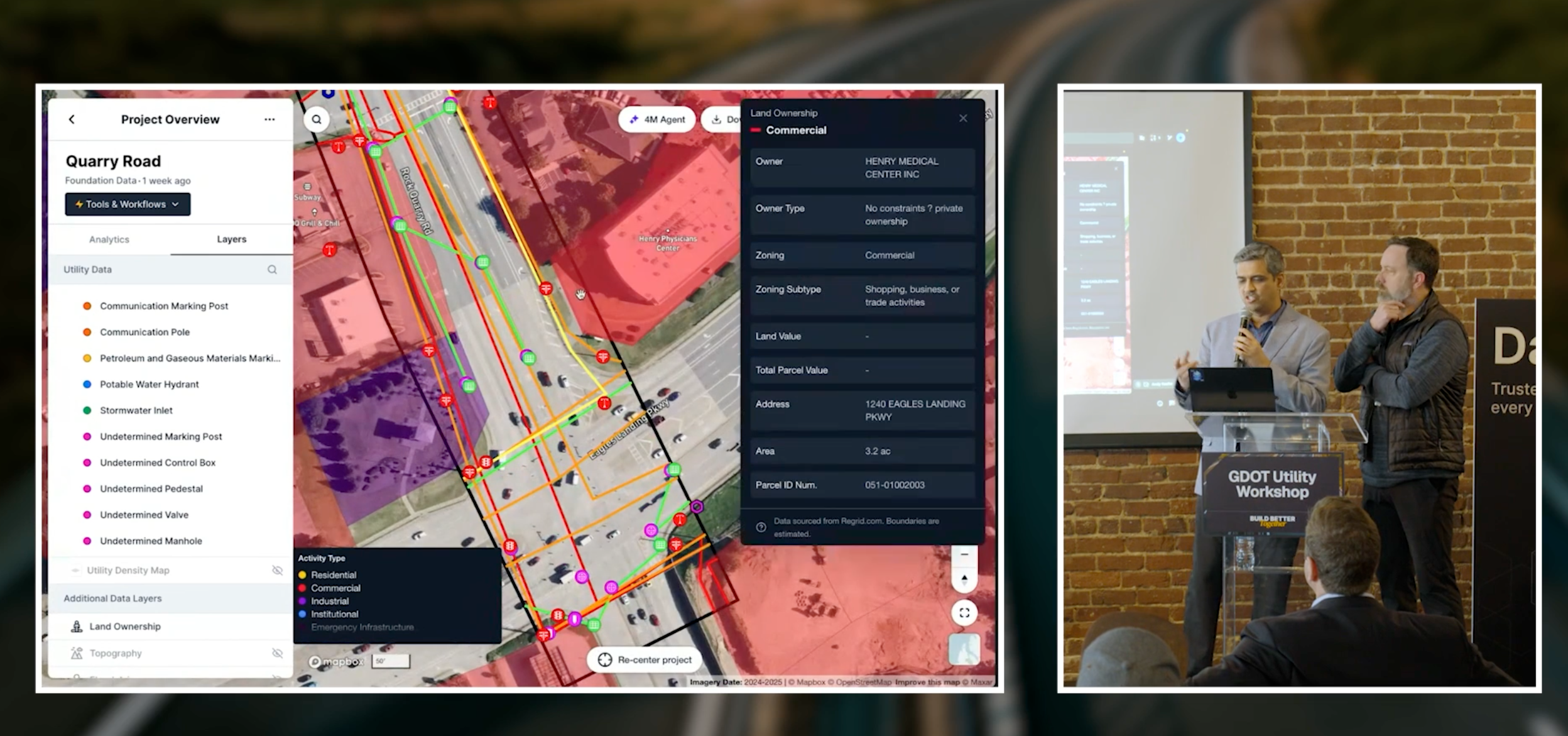
Scene 1: Field Investigation. The scenario started with a question every DOT and engineering team faces at the beginning of a project: what's in the ground? 4M's AI Conflation Engine synthesized public records, GIS data, permits, and street-level imagery to produce a comprehensive utility map within an hour — showing probable utility lines, on-surface objects like poles and manholes, and even historical road markings and locate flags.
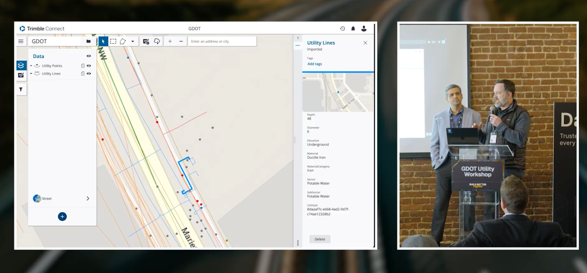
Through the integration with Trimble Connect, 4M’s utility data flowed directly into the Trimble ecosystem via API. The data was then pushed to a field crew using Trimble SiteVision, an augmented reality tool that allows users to visualize 3D spatial data, BIM models, and GIS information in the real world using a mobile device. As the crew walked Marietta Street, they could see 4M's utility data overlaid directly onto their surroundings — gas lines near foundations, fiber under sidewalks, and water infrastructure that had no surface markings at all. It gave them a clear picture of what was underground, in context, before the project began.

The goal wasn't pinpoint accuracy. It was eliminating blind spots before work begins. As 4M's Kaustubh Page explained: "You can't communicate what you don't know." The data provides teams with a starting point for coordination and investigation — identifying which utility owners are present, where risks are concentrated, and where to focus more detailed SUE work.
Scene 2: Conceptual Design. WSB used automated scripting in Bentley OpenRoads to convert the 4M data into a full 3D model — a process that took approximately 4 days, compared to the months it typically required. That model was pushed back to Trimble SiteVision, allowing the field crew to walk the proposed design overlaid against existing utilities and identify conflicts in real time.
Nick Fields framed the broader significance. GDOT doesn't view this as a design-phase tool — they see it as full lifecycle asset management. His team is already using 4M for emergency response when design plans aren't available, for permit review when utility presence is uncertain, and for construction-phase identification of previously unknown facilities. "The facilities in the right-of-way aren't going anywhere," Fields said. "We plan to manage this asset from cradle to grave."
Ed Shappell from WSB reinforced the practical impact: "It used to take us months to model out utilities. We do it in a week."
What's Next
The Atlanta event was the first stop in 4M's Build Better Together Roadshow series — and it set a high bar.
The real value of the day wasn't the sessions or the technology demos. It was the room itself — utility owners sitting next to highway contractors, local government officials trading notes with DOT leadership, technology providers hearing directly from the people who use data in the field every day. That proximity — and the honesty it produces — is what makes this series different.
As Fields said in his keynote, “When we align our goals, utilities, government, and various industries, we don't just build roads. We build opportunity.”\
The themes that surfaced were consistent across every session. Georgia's infrastructure challenges are fundamentally coordination challenges. Solving them requires earlier communication, shared data that bridges the office and the field, and serious investment in the next generation of people who will do this work.
As Nick Fields put it in his keynote:
"When we align our goals — utilities, government, and various industries — we don't just build roads. We build opportunity."
None of that happens in isolation. It happens when people, data, and technology come together.
It happens when we build better together.
The next stop is coming. If you want to be in the room where these conversations happen, now is the time to get on the list.\
Recent blog posts

Here's What's New in 4M: July 2026
July brought two updates that give teams more visibility and more ground to work with: a new Admin Dashboard for tracking usage and adoption at a glance, and Foundation Data live in Massachusetts, another step on 4M's path to nationwide coverage by the end of the year. Here's what's new.

Nicole Heger
July 31, 2026


Our Newsletter
Join 7k infrastructure professionals
Get monthly insights on ways to build smarter, faster and safer with Utility AI.