Infrastructure Consulting & Engineering (ICE) Streamlines Field Investigations with 4M
Written by
.avif)
Chris Garafola
Published on
February 5, 2024


Table of contents
Profile:
- No. 1 Design Firm in South Carolina.
- About 500 full-time employees.
- Design-build experts.
- Focus on engineering, design, compliance evaluation inspection (CEI), and utility coordination.
When Infrastructure Consulting & Engineering (ICE) prepares to bid on projects, personnel must often perform time-consuming field research, often in remote areas, to uncover utility data. The firm saw an opportunity to streamline field investigation using 4M's Utility AI Mapping solution, saving hours — if not days — of effort.
Challenge: Time-Consuming Field Investigation
ICE regularly leads design and utility coordination efforts on joint venture infrastructure projects. Some of the firm’s recent projects include widening interstates as part of a massive push to improve transportation infrastructure throughout the state of South Carolina. “Improving interstate corridors is a top priority for the state right now,” explains Jason McNaughton, Utility Coordinator at ICE. “The goal is to quickly build out many of our interstates to three lanes each way.”
When ICE is pursuing a new infrastructure project, McNaughton travels to the site — often in a remote area — to perform field investigation. For one such project, he drove more than two hours each way to Captain Bill Road off Interstate 95 in Ridgeville. McNaughton contacted the local utility company and met with them near the project site to learn more about the water and sewer lines that would need to be considered. He then went to the site and found a fiber line and a telephone line within the project area.
With three decades of industry experience and many local contacts, McNaughton is a pro at finding the information he needs. Yet commuting to rural project sites, making phone calls, and setting up in-person meetings all take time — time that’s valuable when ICE is rushing to bid on a project.
Solution: Utility AI Mapping Delivers Reliable Data, Fast

At the RFP stage, ICE doesn’t need 100 percent accurate utility data in hand — but the more information the firm can uncover before a bid, the better. “If we know there’s a sewer line across the interstate, that’s potentially a million-dollar problem,” he says. “When we highlight project risks ahead of time and talk about how we’ll deal with them, we distinguish ourselves from the next firm who might not come to the table with as much information.”
To reduce the effort involved in field investigation before bidding on projects, ICE decided to incorporate new technology — and chose 4M Analytics.
McNaughton requested a report from 4M on the Captain Bill project area and compared it with his on-the-ground research. “I was skeptical, but 4M hit a home run in verifying everything I had uncovered, including water and sewer lines that are harder to locate,” he says. “Seeing the accuracy of 4M’s results gives me confidence.”
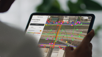
A task that took McNaughton a full day — between spending several hours in the car and meeting with local utility owners — can now be completed without leaving his desk with the click of the mouse. With 4M, McNaughton is able to visually validate the utilities on a project from his office while he professionally verifies them in the field.
Results: Reducing Field Investigation Time for Cost Savings and More Wins
Key Takeaways:
- ICE's utility coordinators can access detailed utility data for a project remotely from their office.
- Armed with precise and reliable utility data, ICE can prepare for further field verification with greater confidence.
- With 4M, ICE saves hours of commuting and field investigation time.
- Faster data gathering means more efficiency in responding to RFPs — and more winning bids.
Seeking out utility data is an increasing priority for ICE — even at the RFP stage. “In my five years of being here, utilities have gone from the last item of discussion to the first thing we talk about,” says McNaughton. “It used to be ‘Let's talk design, right-of-way, hydro and environmental. Okay, now let's get the utilities.' Today, utilities are almost the first thing we discuss due to the costs, delays, and everything else they impact.”
Utilizing 4M data in the earliest stages of a project's lifecycle reduces field investigation time, lightening the load for utility coordinators and bolstering the firm’s agility to place bids. “The further away from my home base a potential project site is, the more time it’s going to consume for me to go there and do field investigation,” McNaughton says.
In contrast, he can access 4M's standard utility information almost instantly. “We see an opportunity to use it for feasibility studies and for pursuing RFPs on short timelines, where you just don’t have time to get out in the field and do an investigation.”And saving time means saving money. Sending utility coordinators to the field is costly, often incurring expenses for gas, lodging, and overtime hours.
Ultimately, McNaughton sees 4M data as a tool to help him do his job more efficiently. “Having access to this data can increase our confidence and precision when doing a field investigation, especially on these interstate projects.”
Recent blog posts

Our Newsletter
Join 7k infrastructure professionals
Get monthly insights on ways to build smarter, faster and safer with Utility AI.


