Michigan Department of Transportation Enhances Planning and Utility Coordination with 4M's AI-Powered Infrastructure Intelligence
Written by

Tamar Shafrir
Published on
May 18, 2026
Table of contents
AUSTIN, TX — 4M Analytics (“4M”), the utility data platform for infrastructure intelligence, announces today that the Michigan Department of Transportation (MDOT) is now using 4M’s utility data to manage, design, and construct its statewide transportation network. While carrying out its $2.6 billion Highway Investment capital program for 2026 and pursuing its mission for excellence across 10,000 miles of highway infrastructure, MDOT can now incorporate comprehensive, reliable, and instantly available utility data to support ongoing and future projects and long-term planning.
Traditionally, public agencies have collected utility information through costly, time-consuming, and labor-intensive processes, from records research to on-site locating. Crucial utility data is often incomplete, inaccurate, or inaccessible, introducing cost-schedule uncertainty, inefficiencies, and safety hazards across every phase of the project lifecycle. In a survey of state transportation agencies by the National Cooperative Highway Research Program (NCHRP), utility issues were ranked as the most common risk factor for project outcomes, affecting 81% of new construction projects and 89% of reconstruction projects. But now, by incorporating 4M’s utility intelligence into existing workflows, MDOT is better equipped to mitigate risks, improve utility coordination, and deliver more projects on time and on budget.
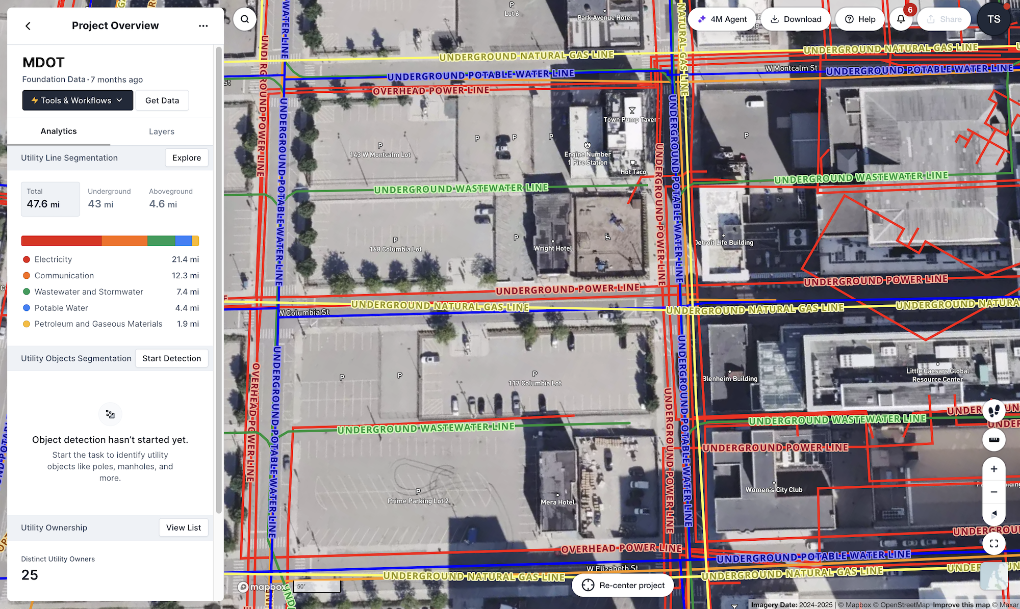
4M is the leading platform for utility intelligence and the most comprehensive and up-to-date utility data set available for US infrastructure. 4M uses AI to collect and georeference millions of utility records from GIS, blueprints, as-builts, and permits; detects utility objects (manholes, inlets, poles, hydrants, and more) from satellite and street-level imagery using computer vision; and generates lines based on network topology without the need for records. Unlike traditional utility locating, 4M’s data is collected 100% remotely, making utility locations available to project stakeholders long before putting boots on the ground. In the first three months of deployment by MDOT, 4M delivered over 1.8 million linear feet of subsurface utility data, accelerated subsurface visibility across active corridors, and enabled identification of high-risk crossings and dense utility clusters prior to letting.
Itzik Malka, CEO and co-founder of 4M, states, “Transportation officials have long contended with outsized utility-related risk due to a lack of foundational data, but MDOT is pioneering a new way for public agencies to solve conflicts, optimize relocations, and prevent damages. By implementing AI-powered utility intelligence, MDOT and its stakeholders will deliver safer roads, more efficiently and cost-effectively, to Michigan residents and taxpayers.
About 4M
4M is the utility data platform for infrastructure intelligence. Powered by proprietary data and AI, verified by geospatial experts, 4M delivers instant, reliable utility intelligence you can trust, validate, and access across teams, technologies, and workflows. Trusted by WSP, Stantec, AtkinsRéalis, HNTB, MasTec, TxDOT, GDOT, Michigan DOT, MnDOT, and CDOT, 4M enables teams to identify risks earlier, keep crews safer, and deliver projects on time and on budget. Founded in 2019, 4M is backed by Insight Partners, Viola Ventures, and Waze’s former CEO. Learn more at www.4manalytics.com.
Tamar Shafrir
A dedicated researcher that doesn’t stop investigating until she reaches the truth, no matter how hard it is to accept or comprehend (and there are a lot of those in our industry). Tamar took her first career steps in architecture and design, both as a practitioner and a journalist. Throughout her journey, her curiosity has taken her all across the globe, from North America through Europe to the Middle East, discovering and explaining the micro and macro challenges of the industry. Today she focuses most of her efforts on unlocking the challenges of the subsurface, through research and education.
Recent blog posts


Our Newsletter
Join 7k infrastructure professionals
Get monthly insights on ways to build smarter, faster and safer with Utility AI.