How We're Building the First Nationwide Map of Utilities
Written by

David Horesh
Published on
June 13, 2023


Table of contents
One of the questions we most often hear is, “Where do you get your data?”
A close second? “How do you compile that data to create a visual map?”
In other words: How does 4M utility mapping work?
Our goal is to give professional engineers a baseline of utility data that the different project stakeholders can agree upon. To achieve that, we collect raw data from millions of sources, including remote sensing technology, satellite imagery, and public records.
Then, we piece it together with a variety of self-developed AI capabilities and verify it using both state-of-the-art computer vision and proprietary mapping techniques.
In this post, we’ll take a closer look at the data sources and the technology we utilize.

Data Sources
To create comprehensive utility maps, we pull in data from many available sources, including public and private records and satellite and aerial images. More specifically, in the U.S., our mapping data comes from:
1. Public Records
a. State-level source Government agencies: Departments that are responsible for sharing utility location data, such as the department of energy & water.
Research institutions: Universities, colleges, and other research institutions occasionally collect and publish utility location data.
Non-profit organizations
b. County & Municipal-level sources:
- Maps: Counties & municipalities often provide interactive or PDF records of roads, highways, utilities, and other types of infrastructure.
- Geospatial data: Occasionally counties & municipalities provide GIS data that includes imagery of features such as roads, utilities, and others.
2. Private records
Private company sources (data partnerships) - such as utility owners often maintain detailed records of the location of the infrastructure that supports their services.
3. Imagery
We use a wide variety of public sources and known imagery programs, collaborating with some of the largest commercial providers in the U.S. for satellite and aerial imagery.
Technology
4M’s core technology is a data mapping powerhouse that collects, digitizes, geo-references, indexes and analyzes millions of data sources, generating reliable, complete and up-to-date infrastructure base maps.
Digitizing record sources
Utilizing big data, computer vision, and AI, 4M’s engine processes millions of duplicative, incomplete, and outdated public GIS layers and validates them against satellite and aerial imagery and engineering data, conflating them into detailed and reliable maps.
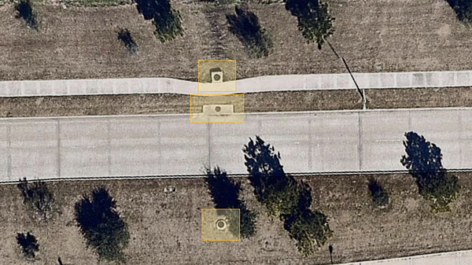
Evidence detection
4M utilizes computer vision to create reliable and accurate geo-referenced evidence which indicates the existence and accurate location of on-surface and subsurface utilities. This is performed by implementing multi-disciplinary techniques, including AI-based object detection, surface change detection, remote sensing, and computer vision.

Geo-fusion engine
At its core, 4M’s platform is powered by its geospatial AI-based fusion engine, which cohesively integrates all proprietary digitized data elements and layers, registering missing infrastructure objects, verifying the mapping quality, and maximizing reliability.
By combining and correlating data from a wide variety of sources, 4M creates high-quality utility maps that are comprehensive and reliable. With these maps as tools, you can plan projects faster and more efficiently.
You’ll go into projects more aware of existing subsurface infrastructure—and having more information will allow you to minimize utility conflicts and strikes, reduce liability, and gain the ability to deliver projects with confidence.
David Horesh
If you ask David what’s the one thing he cares about most when it comes to the construction industry, he’ll tell you one thing and one thing only - the problem space. What are the challenges that the industry is facing today and how can we be part of the solution? As the host of the Utility Strategy Podcast, David enjoys the opportunity of talking to a wide range of industry leaders about all the challenges the civil engineering industry has to offer (and there are a lot of them). If you’re not following David on LinkedIn yet - you should.
Recent blog posts


Our Newsletter
Join 7k infrastructure professionals
Get monthly insights on ways to build smarter, faster and safer with Utility AI.