The ultimate source of utility data
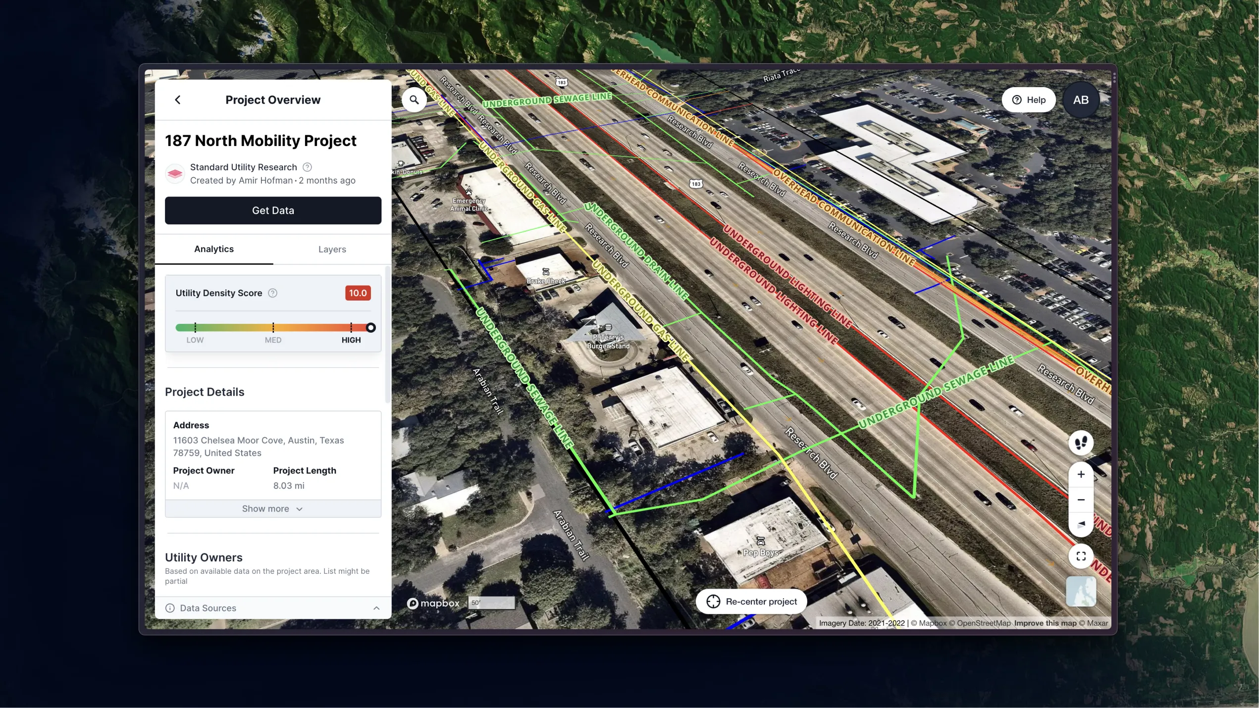
Start utility risk mitigation and coordination as early as pre-design. Without leaving the office. Without leaving your desk.

.svg)


What Is Underground Utility Mapping?
TL;DR:
- Underground mapping is the process of locating and mapping underground utilities before construction begins.
- It's important to map utilities such as gas lines, communication cables, sewer lines, water pipes, and electric lines to minimize risks and prevent accidents.
- Underground mapping offers benefits such as eliminating delays, improving safety, and streamlining communication.
- Tools used for underground mapping include electromagnetic locators, ground-penetrating radar, acoustic methods, potholing, and aerial inspection.
- The level of accuracy and cost of underground mapping varies depending on the quality level chosen, ranging from Quality Level A (highest accuracy) to Quality Level D (least definitive).
What Is Underground Utility Mapping?
Underground utility mapping shines a light on underground infrastructure before shovels hit the dirt. This crucial step pinpoints the location of power lines, gas pipes, cables, and, of course, vital water and sewer systems. Knowing where these hidden assets lie minimizes risks, keeps construction on track, and prevents costly accidents.
Which utilities need underground mapping?
The complexity of underground infrastructure increases every year. In many urban areas, it’s hard to find a place to dig that won’t impact utilities already in place. These underground utilities come in many forms, but here are some of the most common:
- Television or communication cables: Buried just beneath the surface, a network of communication cables transmits vital data for telephones, internet, and television. Accidental damage can result in service outages, repair costs, and potential legal consequences.
- Gas lines: These transport potentially hazardous natural gas, necessitating utmost caution during excavation. You can usually see surface markings for gas pipes, but many older or abandoned lines are unmarked.
- Metal and concrete pipes: Older metal and concrete pipes, often unregistered and of unknown composition, may carry water, sewage, or even gas.
- Sewer lines: Undetected excavation near underground sewer lines poses significant environmental and public health risks. Disruptions can lead to contaminated soil, sewage overflows, and potential waterborne diseases.
- Water pipes: This critical network delivers essential water for drinking, irrigation, and industrial purposes. Damage to water pipelines can cause significant property damage, service disruptions, and legal repercussions.
- Electric lines: While overhead lines are common in some areas, buried power cables provide electricity in others. Striking these conductors can endanger workers and cause widespread power outages, disrupting essential services.
Importance and benefits
It’s easy to see the importance of underground mapping when looking at underground utilities like gas or sewage lines, which can be deadly if not dealt with properly.
However, not all projects are created equal. Before investing resources in finding the most detailed information, there are a few important questions to ask, Jim Anspach, P.G., Dist.M.ASCE, NAC, points out in a recent webinar: “Why do I need the information? What’s the return on investment of that information? How reliable does it need to be for this specific task?”
Because it’s not always possible to get all the information you need, Anspach suggests that you should color your decisions for your project based on the accuracy of the data you can get.
Underground mapping offers a comprehensive array of benefits for construction projects of any scale. Its primary advantage is its ability to proactively mitigate risk and optimize efficiency. By consulting a detailed map of underground utilities — including pipes, cables, and lines — construction teams can make informed decisions early in a project, yielding several benefits:
- Eliminating delays that often arise from encountering unexpected subsurface infrastructure during excavation or construction.
- Improving safety by accurately pinpointing utilities, enabling contractors to implement proper safety protocols, such as maintaining safe digging distances and utilizing appropriate machinery.
- Streamlining communication through access to precise utility data. This allows project stakeholders and utility companies to collaborate effectively, minimizing miscommunication and ensuring the smooth execution of the project.
Investing in underground mapping is not simply a precautionary measure — it's a strategic move. It enhances project safety, optimizes efficiency, and ultimately contributes to cost savings by avoiding costly rework and delays
What is used to map the underground?
Utility locators and civil engineers use several tools to chart the location of underground utilities and structures:
- Electromagnetic (EM) locators: Imagine a metal detector for buried pipes. EM locators use radio waves instead of magnets. They send a signal through conductive materials like metal pipes, then follow the returning signal to pinpoint their location. This works best when connected to an above-ground piece like a valve, but accuracy drops when tracing unseen lines.
- Ground-Penetrating Radar (GPR): Think of GPR as an underground X-ray for utilities. It sends high-frequency radio waves into the ground, which bounce off objects and return to the receiver. Special software analyzes these echoes to create a visual map of buried pipes and cables, showing their depth and material properties. GPR excels at locating metal utilities due to their distinct electrical signatures.
- Acoustic methods: When radio waves struggle, sound waves step up. Acoustic methods emit sound patterns into the ground and measure the time it takes for them to bounce back. By analyzing these echoes, technicians can estimate the depth and location of buried objects, especially in sandy or saturated soil where GPR falters.
- Potholing: Picture meticulously digging small holes to peek underground. Potholing offers the most precise, hands-on approach to utility location. Crews dig test pits to directly see buried lines, determining their exact position, depth, type, and even potential damage. While time-consuming and labor-intensive, potholing plays a crucial role in preventing accidental utility damage during construction projects, saving time and money in the long run.
- Aerial Inspection: While it might seem counterintuitive, surveying infrastructure from above can yield valuable information about underground utilities for large-scale projects. Traditionally done with expensive helicopter aerial inspection, results took a long time to process. But as ARGO Labs co-founder Varun Adibhatla points out in an episode of the Utility Strategy Podcast, 4M's use of satellite imagery for the same process has reduced the wait time from 72 hours for a locate to nearly instant.
How to do underground utility mapping?
Each field investigation tool we’ve discussed takes time to use and varies in cost. Taking a subsurface utility engineering perspective lets you determine what kind of data you need for a particular project. This approach breaks down utility data into four quality levels:
- Quality Level A: The highest assurance of accuracy comes with Quality Level A. This level employs techniques like vacuum excavation to meticulously pinpoint and chart the position of buried utilities. While you still physically have to dig and check locations, this method minimizes disruption to the surrounding environment and allows for near-flawless mapping of underground infrastructure. Unfortunately, the field investigation involved makes acquiring Quality Level A the most expensive.
- Quality Level B: Quality Level B utilizes non-invasive geophysical methods, such as Ground-Penetrating Radar (GPR), to identify the presence and approximate location of underground utilities. While offering valuable insight, these techniques lack the pinpoint accuracy of Quality Level A, leaving some room for potential discrepancies.
- Quality Level C: Quality Level C focuses on corroborating existing information through onsite surveys. Consultants meticulously search for visual indicators of utilities, such as sewer covers or valve boxes, and compare their findings with available records. This level can provide useful information, but its reliance on surface indicators means that the exact location can be a mystery once the utility goes underground.
- Quality Level D: Quality Level D represents the least definitive level of assurance. This level relies solely on the consultation of existing utility records and readily available information. While offering a starting point, its dependence on potentially outdated or incomplete documentation limits its reliability and suitability for critical projects.
At 4M, we've set out to modernize the process of underground mapping. Our Utility AI and Analytics Solution transforms the way utility infrastructure mapping is done, delivering reliable, real-time utility data to mitigate risk during the earliest, most cost-effective stages of construction for any project at any scale.


Like this article? Share it.


